Introduction
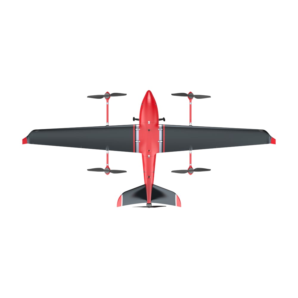
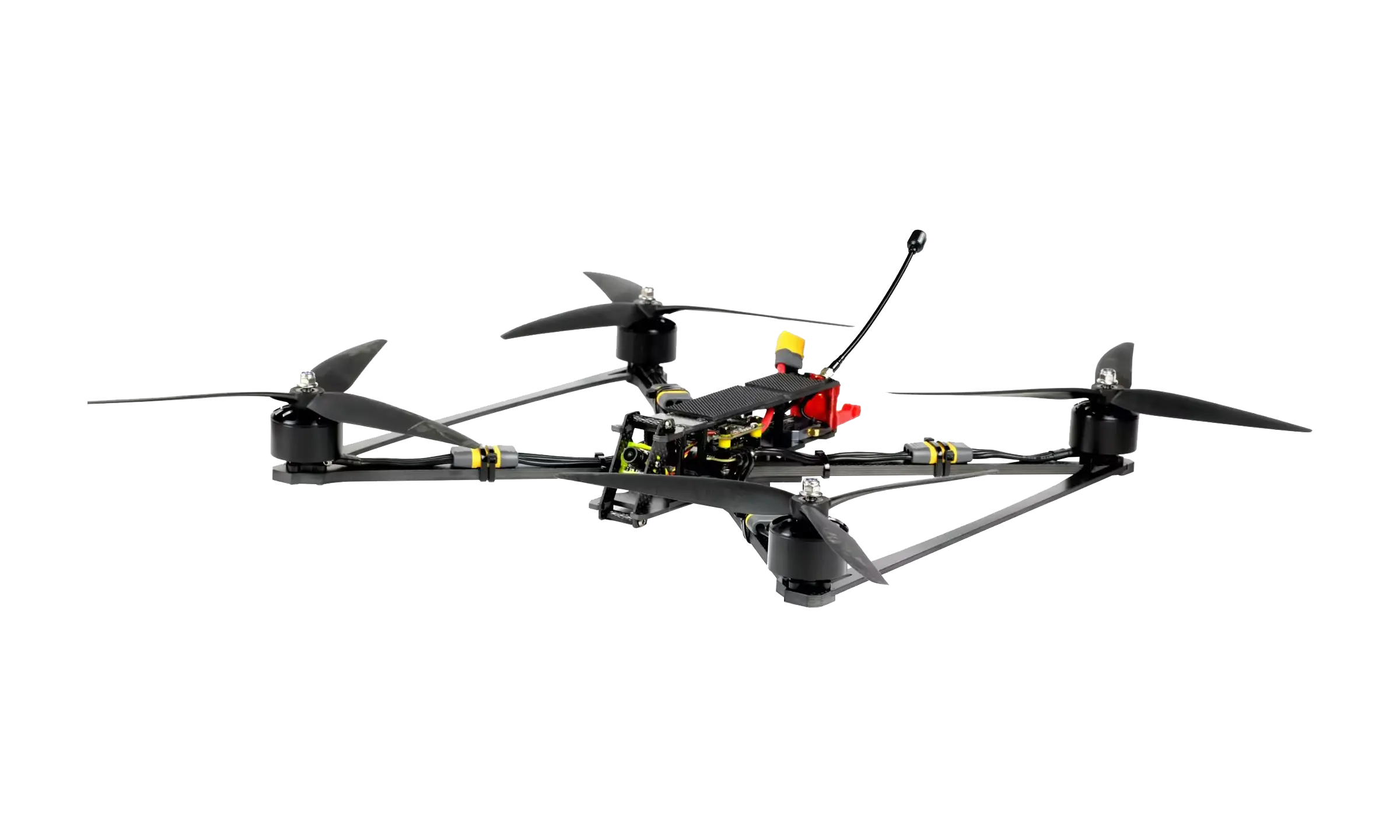
In today’s fast-paced geospatial industry, accuracy, efficiency, and adaptability are critical for success. MMC’s advanced LiDAR UAV Mapping Solution, featuring the Skylle Ⅱ drone paired with the Thyea X2C five-lens surveying camera, delivers unparalleled precision, speed, and flexibility for modern mapping challenges.
Whether you’re working on urban digital twins, topographic surveys, or infrastructure inspections, this high-performance UAV-LiDAR system is designed to maximize productivity while reducing operational costs.
Why Choose MMC’s Skylle Ⅱ + Thyea X2C LiDAR UAV Solution?
1. Unmatched Precision with RTK/PPK High-Accuracy Positioning
The Skylle Ⅱ UAV integrates RTK (Real-Time Kinematic) and PPK (Post-Processed Kinematic) technology, ensuring centimeter-level positioning accuracy—essential for high-precision 3D mapping and surveying.
- RTK mode provides real-time corrections for immediate data validation.
- PPK mode ensures reliable data even in GNSS-challenged environments.
Ideal for:
✔ Digital city modeling (BIM, smart city planning)
✔ Large-scale topographic surveys (DTM/DSM generation)
✔ Power line inspections & corridor mapping
2. LiDAR + Five-Lens Camera: Superior Data Fusion
The Thyea X2C is a multi-sensor powerhouse combining:
- High-resolution LiDAR for dense point cloud generation
- Five-lens oblique camera array for true-color 3D textured models
Key Advantages:
✅ Simultaneous LiDAR and photogrammetry data capture—eliminating the need for multiple flights.
✅ Seamless integration with Skylle Ⅱ’s modular payload system—quick-swap compatibility.
✅ Enhanced feature extraction for AI-driven object recognition (buildings, roads, vegetation).
3. Optimized for Efficiency & Scalability
- Fast Deployment: The Skylle Ⅱ’s foldable design enables rapid setup—ready to fly in minutes.
- Extended Flight Time: With up to 60 minutes of endurance, it covers large areas in a single mission.
- Smart Automation: Pre-programmed flight paths, AI-powered obstacle avoidance, and one-click data processing streamline workflows.
4. Industry-Leading Applications
🛰️ Digital Twin & Smart City Development
- Generate hyper-accurate 3D city models for urban planning, disaster management, and virtual simulations.
- Automated feature extraction for infrastructure monitoring (roads, bridges, utilities).
⚡ Power Line & Utility Inspection
- Detect vegetation encroachment, structural defects, and sagging conductors with millimeter-level LiDAR precision.
- Thermal imaging compatibility (optional) for fault detection in electrical grids.
🏔️ Topographic & Mining Surveys
- Rapid terrain modeling for open-pit mines, quarries, and construction sites.
- Volume calculations, cut-fill analysis, and slope stability monitoring with sub-10cm accuracy.
🚧 Transportation & Corridor Mapping
- Highway, railway, and pipeline corridor surveys with seamless data stitching.
- Automated change detection for construction progress tracking.
Technical Specifications
| Component | Specification |
|---|---|
| UAV Model | Skylle Ⅱ |
| Max Payload | 10 kg (expandable to 15 kg with Skylle Ⅱ-P) |
| Flight Time | Up to 60 minutes (with LiDAR payload) |
| Positioning | RTK/PPK (GNSS: GPS, GLONASS, BeiDou, Galileo) |
| LiDAR Sensor | Thyea X2C (5-lens oblique + LiDAR) |
| Point Cloud Density | Up to 300 pts/m² (adjustable) |
| Scanning Range | 450m (max) / 200m (optimal for high-res) |
| Photogrammetry | 48MP per lens, global shutter |
| Data Output | LAS, LAZ, OBJ, FBX, GeoTIFF, etc. |
| Software Compatibility | Pix4D, Global Mapper, AutoCAD, ArcGIS, TerraSolid |
Why MMC Stands Out?
✔ End-to-End Solution: From data acquisition to AI-powered analytics, we provide full workflow integration.
✔ Proven Reliability: Trusted by government agencies, survey firms, and engineering giants worldwide.
✔ Customizable Workflows: Need thermal imaging, multispectral, or gas detection? Our modular system adapts to your needs.
Get Started Today!
Upgrade your surveying capabilities with MMC’s Skylle Ⅱ + Thyea X2C LiDAR UAV Solution.
📞 Contact our experts for a free consultation & demo!
📩 Email: sales@mmcuav.com
🌐 Website: www.mmcuav.com
🚀 Fly Smarter. Map Faster. Build Better.
About MMC
MMC is a global leader in UAV LiDAR and photogrammetry solutions, specializing in high-precision aerial mapping for surveying, construction, and smart infrastructure. Our cutting-edge drones, sensors, and AI-powered software redefine what’s possible in geospatial intelligence.
🔹 ISO 9001 Certified
🔹 100+ Successful Projects Worldwide
🔹 24/7 Technical Support
Join the future of mapping—with MMC. 🛰️
Comments