Heritage Preservation
MMC Drones delivers millimeter-accurate 3D reconstructions of heritage sites using advanced drone mapping. Our non-invasive technology enables precise condition monitoring, restoration planning, and digital archiving while protecting fragile structures. Ideal for conservationists and researchers.
Painpoints
- – Absence of Visualized 3D Models for Protective References and Historical Records.
- – Time-Intensive Ground Measurements and Elevated Personnel Risks.
Advantages
- Generate accurate 2D and 3D models of the historical to properly plan conservation efforts and research purposes.
- Optimize on-site collection methods with drone-based data capture.
Solution

Portable Drone Surveying & Mapping Solution
Skylle Ⅱ + MMC X2C: Portable drone solution for construction heritage preservation—centimeter precision via RTK/mechanical shutter, one-tap 3D mapping.
- Ultra-portable: Foldable design, lightweight camera—easy transport across tight heritage sites, quick setup.
- Centimeter accuracy: RTK positioning + mechanical shutter—captures intricate details (carvings, cracks) for preservation.
- One-tap 3D mapping: Auto-generates high-quality 3D models/point clouds—simplify documentation.
- Low-interference: Quiet flight, gentle on fragile sites—preserves heritage without disruption.
Drone Platform
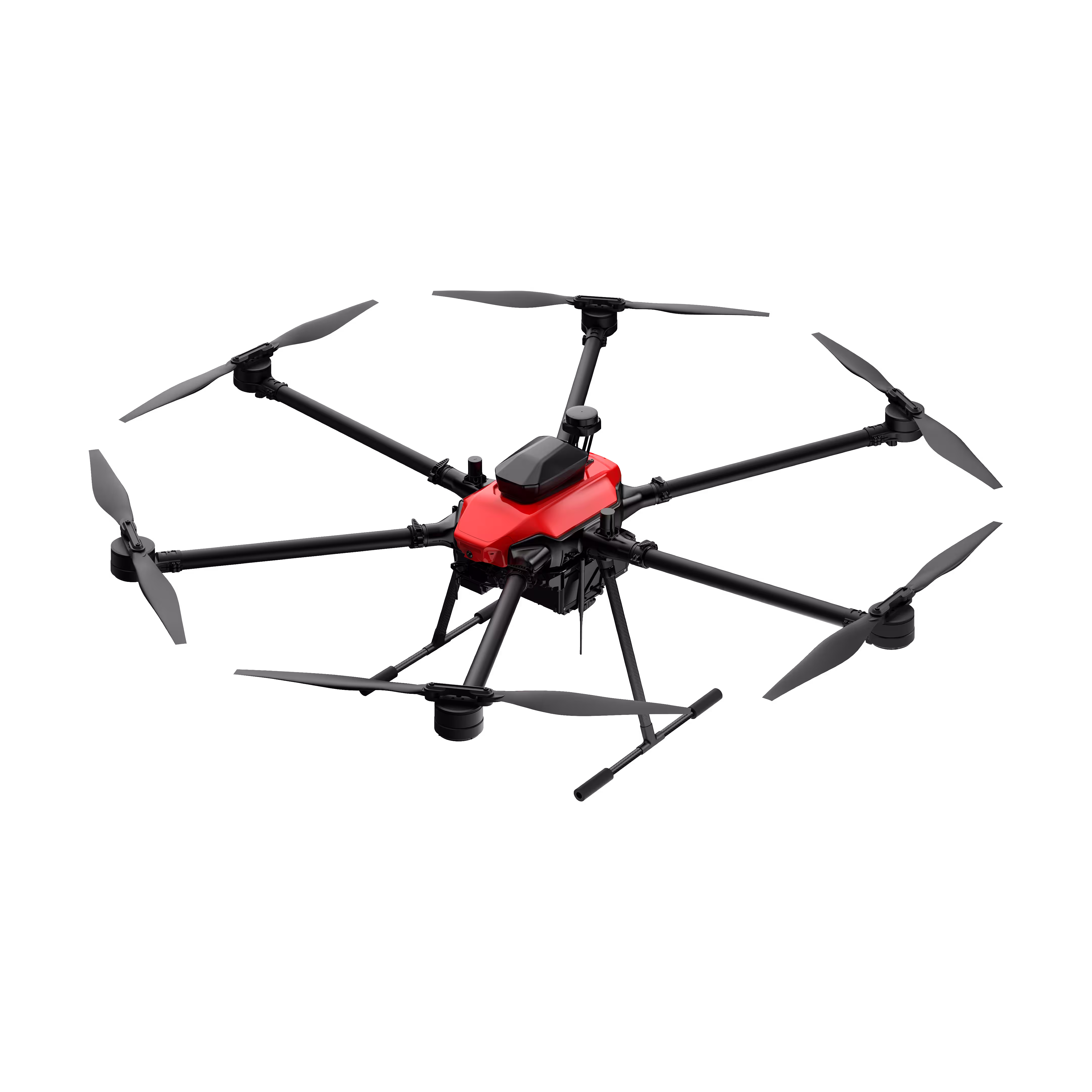
Skylle Ⅱ
Hexacopter Industrial Heavy-Lift Drone - 10kg Payload | 60min Flight Time | RTK cm-Level Positioning | IP54 Rated Read More
Learn MorePayload And Software
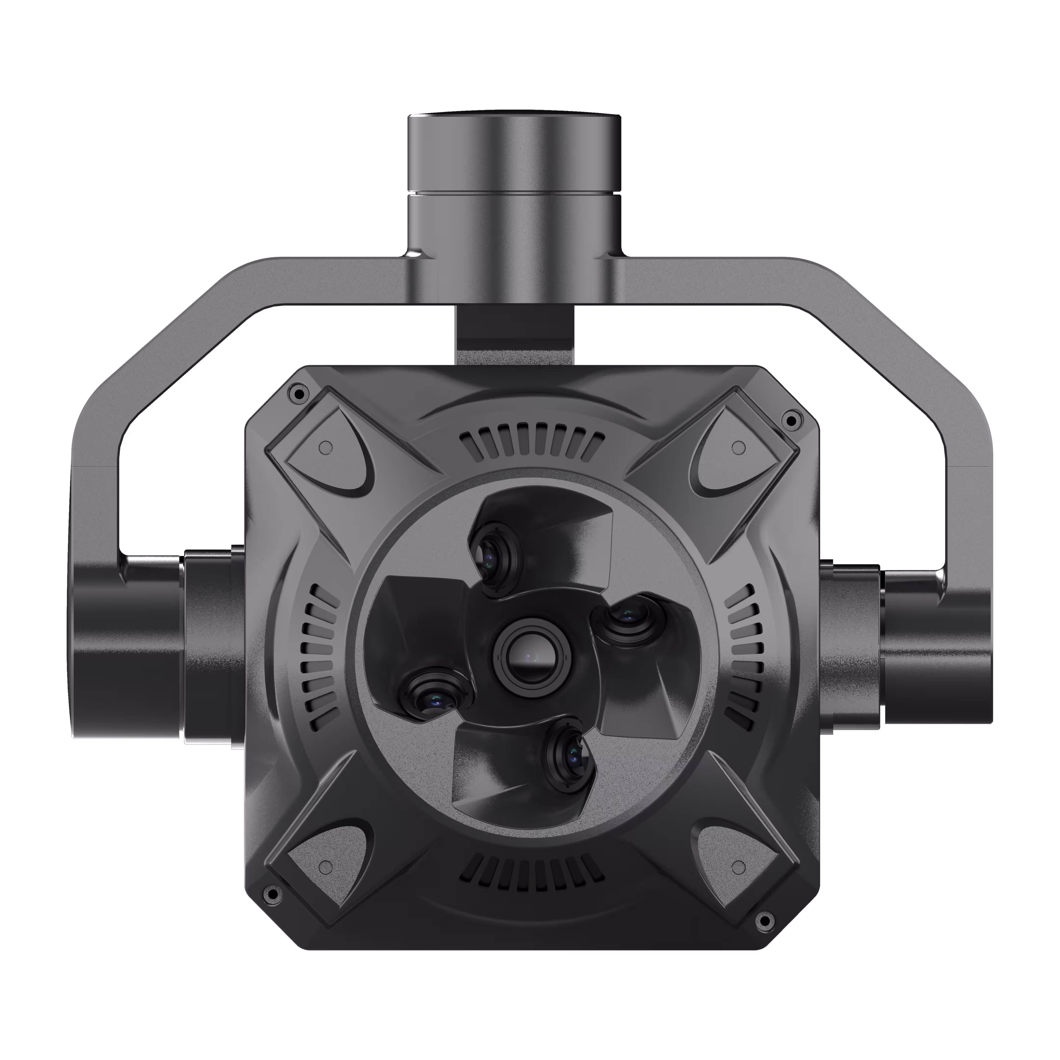
X2C
A professional aerial survey camera designed for 3D modeling, capturing multi-angle spatial images to deliver realistic terrain/texture details for topographic, real estate, and architectural mapping. Read More
Learn MoreSkylle Ⅱ + MMC X2C: Preserve Heritage with Precision—Portable Drone Mapping for Construction’s Cultural Legacy
Heritage preservation in construction demands a delicate balance: capturing intricate details of historic structures without intrusion, while delivering data precise enough to guide restoration. Traditional surveys—time-consuming, labor-intensive, and prone to disruption—risk damaging fragile sites or missing critical nuances. Introducing the Skylle Ⅱ Portable Drone Surveying & Mapping Solution, paired with the MMC X2C 5-Lens Photogrammetry Camera. Engineered for heritage teams, this ultra-portable system combines centimeter-level accuracy, one-tap 3D modeling, and ease of use—empowering you to document, analyze, and protect cultural landmarks with unprecedented precision.
Why Skylle Ⅱ + MMC X2C? Built for Heritage, Designed for Care
1. Ultra-Portable: Navigate Tight Spaces, Protect Fragile Sites
Historic sites—whether ancient ruins, centuries-old cathedrals, or delicate monuments—rarely accommodate heavy equipment. Skylle Ⅱ’s carbon fiber one-piece frame (17.2kg empty weight) and quick-release arms fold into a backpack-sized case, letting you transport the entire system through narrow corridors or uneven terrain. The MMC X2C camera, at just 1.1kg with a rugged aluminum body, mounts in seconds—no bulky setups, no disruption to sensitive structures. Unpack, assemble, and fly in minutes: preserve heritage without disturbing it.
2. Centimeter-Level Precision: Capture Every Carving, Crack, and Curve
Heritage preservation hinges on detail. Skylle Ⅱ’s RTK positioning and MMC X2C’s mechanical shutter eliminate motion blur and geotagging errors, capturing millimeter-scale features—from ornate stone carvings to hairline cracks—with centimeter-level accuracy. The X2C’s 5-lens system (1 vertical + 4 oblique) synchronizes 2516MP imagery, ensuring no detail is lost—critical for documenting decay patterns or guiding restoration. Trust the data to make informed preservation decisions.
3. One-Tap 3D Mapping: Transform Imagery into Immersive Models Instantly
Gone are the days of tedious post-processing. With MMC X2C’s one-tap 3D modeling, Skylle Ⅱ auto-generates high-fidelity 3D models, point clouds, and orthomosaics in minutes. Whether creating a digital twin of a medieval archway or mapping a frescoed ceiling, the system turns raw data into actionable insights—perfect for sharing with architects, conservators, or stakeholders. Preserve heritage digitally before time erodes it physically.
4. Gentle on History, Powerful for Preservation
Heritage sites demand non-invasive tools. Skylle Ⅱ’s low-noise propellers and precise flight control hover safely above fragile surfaces, avoiding contact with aging stone or delicate artifacts. MMC X2C’s UV-resistant enclosure and -20°C~65°C operating range stand up to outdoor conditions, from sun-baked ruins to damp catacombs—ensuring reliable performance wherever history lives.
Preserve the Past, Build the Future: Heritage Mapping Reimagined
With Skylle Ⅱ + MMC X2C, heritage preservation moves from painstaking manual work to efficient, precise documentation. Whether surveying a historic district, documenting a restoration project, or creating an archive for future generations, this solution lets you:
✅ Capture fragile sites without physical contact.
✅ Generate 3D models that reveal hidden structural details.
✅ Share data seamlessly with global preservation teams.
Ready to Protect History with Innovation?
Skylle Ⅱ + MMC X2C isn’t just a drone system—it’s a bridge between past and future. Contact us today to demo how portable, precise drone mapping can safeguard the heritage your project aims to honor.
Skylle Ⅱ Drone | MMC X2C Camera | Built for Heritage. Built for Precision.