Disaster Prevention and Response
MMC’s Disaster Prevention and Response solution delivers aerial thermal and visual data to boost risk detection, response speed, and safety during natural disasters.
Painpoints
- – The absence of updated terrain information and situational awareness can severely hinder an effective response.
- – Entering a disaster zone without real-time updates can leave response teams blind to evolving conditions.
- – Traditional data collection methods for post-disaster recovery struggle to grasp the full scope of damage and determine the necessary resources required for efficient rehabilitation efforts.
Advantages
- Provide critical terrain analysis and situational awarness through updated digital models and real-time aerial imagery.
- Ensure safety and proper allocation of response personnel with continuous drone-based aerial support.
- Conduct comprehensive impact assessments and streamline rehabilitation efforts using precise, easily shareable digital models.
Solution
Portable and Rapid Response
- Compact and lightweight design, less than 1kg and easy to carry in the response vehicle.
- Fast and easy deployment, get airborne in around 30 seconds.
- 640 × 480 thermal radiometric sensor for accurate temperature readings.
- Thermal palettes and temperature measurement tools for easy data interpretation.
Drone Platform
X8T
Triple-Camera Thermal Imaging Drone - 48MP | 30X Zoom | 640×480 IR | AI-Powered Night Vision | 47min Flight Time Read More
Learn MorePayload And Software
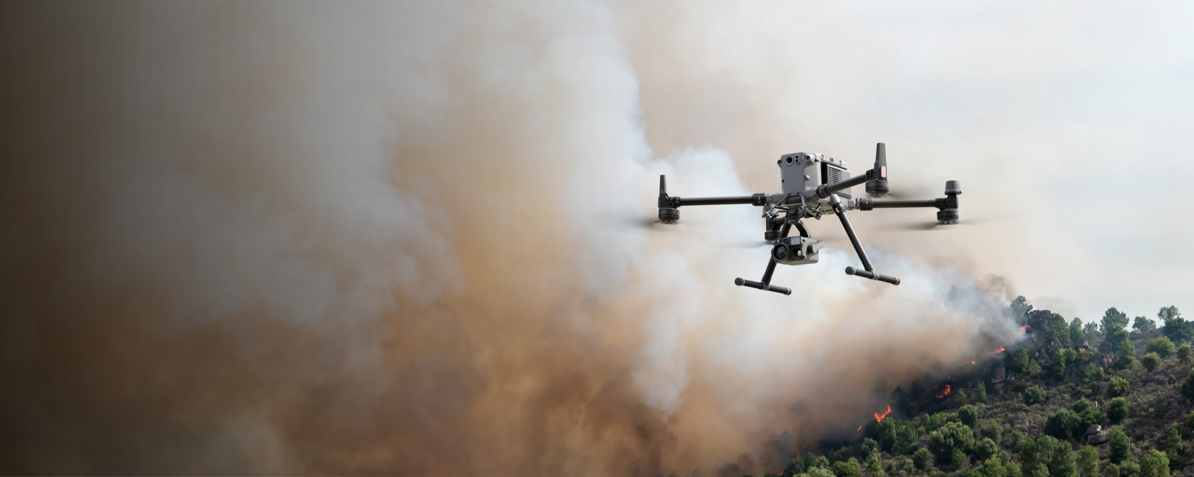
X8T Thermal Drone: Portable and Rapid Response for Disaster Prevention and Response
Compact & Lightweight Design: Enhancing Mobility in Disaster Scenarios
The X8T features a compact, lightweight design with a folded size of 218×106×72.6mm and a maximum takeoff weight of approximately 1190g, making it easy to carry on patrol vehicles. This portability ensures quick transport to disaster sites, supporting timely disaster prevention and response efforts where mobility is critical.
Rapid Deployment: Airborne in 30 Seconds for Time-Critical Missions
Designed for fast action, the X8T achieves operational readiness within around 30 seconds of arrival at incident scenes. Its quick setup minimizes delays, allowing immediate deployment to assess disaster conditions, a key advantage for effective disaster prevention and response.
640×480 Thermal Radiometric Sensor: Accurate Temperature Data for Disaster Assessment
Equipped with a 640×480 thermal radiometric sensor, the X8T delivers precise temperature readings essential for disaster scenarios. It identifies hotspots, structural weaknesses, or heat-related hazards, providing reliable data to evaluate risks and guide disaster prevention and response strategies.
Thermal Palettes & Measurement Tools: Simplifying Disaster Data Interpretation
The X8T includes thermal palettes (e.g., white热, iron红, rainbow) and temperature measurement tools, simplifying data interpretation for disaster response. These features enable quick analysis of thermal patterns, helping teams distinguish critical areas and make informed decisions in disaster prevention and response.
Versatile Aerial Thermal Reconnaissance
- Compact and lightweight design, less than 1kg and easy to carry in the response vehicle.
- Fast and easy deployment, get airborne in around 30 seconds.
- 640 × 480 thermal radiometric sensor for accurate temperature readings.
- Thermal palettes and temperature measurement tools for easy data interpretation.
Drone Platform
X8T
Triple-Camera Thermal Imaging Drone - 48MP | 30X Zoom | 640×480 IR | AI-Powered Night Vision | 47min Flight Time Read More
Learn MorePayload And Software
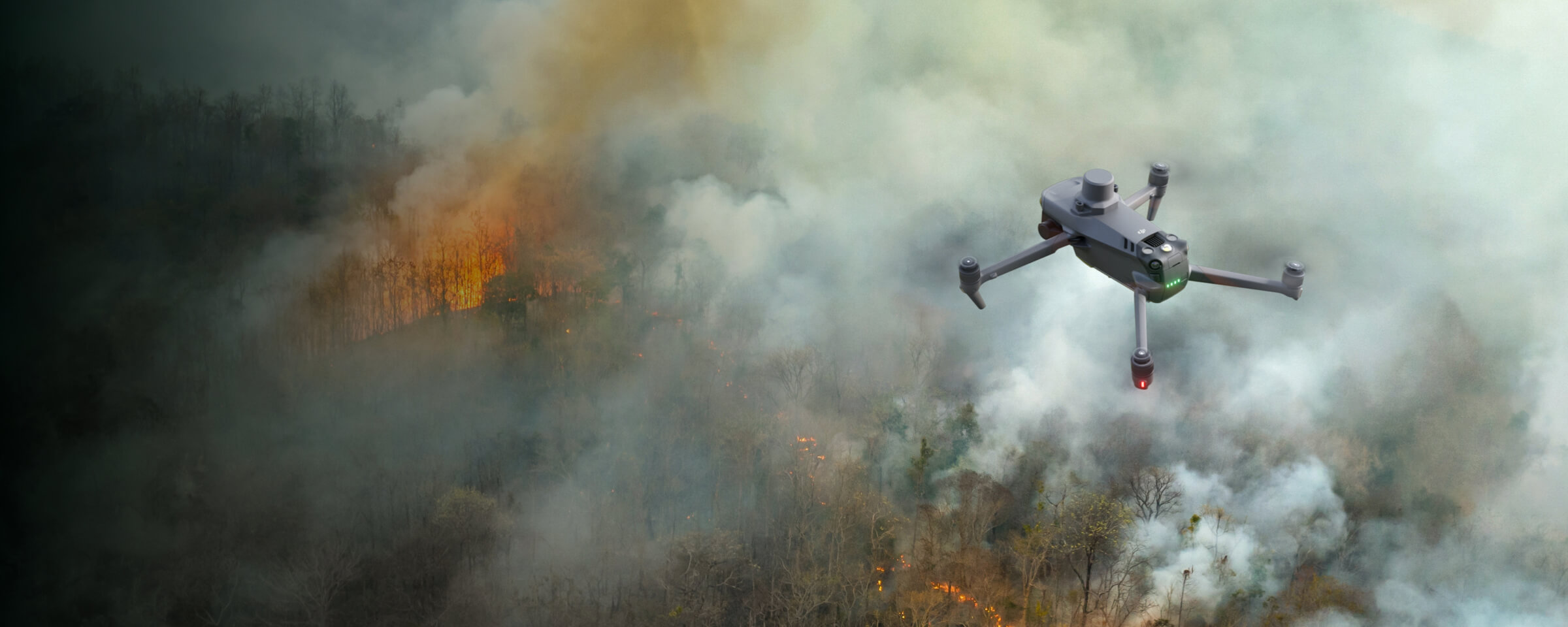
X8T Thermal Drone: Versatile Aerial Thermal Reconnaissance for Disaster Prevention and Response
Compact & Lightweight Design: Boosting Mobility in Disaster Scenarios
The X8T features a compact, lightweight design with a folded size of 218×106×72.6mm and a maximum takeoff weight of approximately 1190g, making it easy to carry in response vehicles. This portability ensures quick transport to disaster sites, enhancing mobility for timely disaster prevention and response missions.
Rapid Deployment: 30-Second Airborne for Urgent Reconnaissance
Designed for fast action, the X8T can get airborne in around 30 seconds. Its quick setup minimizes on-site preparation time, allowing immediate launch to assess disaster conditions—critical for effective disaster prevention and response where every second counts.
640×480 Thermal Radiometric Sensor: Accurate Data for Disaster Assessment
Equipped with a 640×480 thermal radiometric sensor, the X8T delivers precise temperature readings essential for disaster scenarios. It identifies hidden hotspots, structural weaknesses, or heat-related hazards, providing reliable data to evaluate risks and guide disaster prevention and response strategies.
Thermal Palettes & Measurement Tools: Simplifying Data Interpretation in Response
The X8T includes thermal palettes (e.g., white热, iron红, rainbow) and temperature measurement tools, simplifying data interpretation for disaster response. These features enable quick analysis of thermal patterns, helping teams distinguish critical areas and make informed decisions in disaster prevention and response.
Portable Pre and Post Disaster Mapping
- Compact and lightweight design, less than 1kg and easy to carry in the response vehicle.
- Fast and easy deployment, get airborne in around 30 seconds.
- 640 × 480 thermal radiometric sensor for accurate temperature readings.
- Thermal palettes and temperature measurement tools for easy data interpretation.
Drone Platform
X8T
Triple-Camera Thermal Imaging Drone - 48MP | 30X Zoom | 640×480 IR | AI-Powered Night Vision | 47min Flight Time Read More
Learn MorePayload And Software
X8T Thermal Drone: Portable Pre and Post Disaster Mapping for Disaster Prevention and Response
Compact & Lightweight Design: Mobile Mapping for Disaster Scenarios
The X8T features a compact, lightweight design with a folded size of 218×106×72.6mm and a maximum takeoff weight of approximately 1190g, making it easy to carry in response vehicles. This portability ensures quick transport to disaster sites, supporting both pre-disaster risk mapping and post-disaster reconstruction assessments for effective disaster prevention and response.
Rapid Deployment: 30-Second Airborne for Timely Mapping Missions
Designed for fast action, the X8T can get airborne in around 30 seconds. Its quick setup minimizes delays, enabling immediate launch to capture pre-disaster baseline data or post-disaster damage assessments, a critical advantage for time-sensitive disaster prevention and response.
640×480 Thermal Radiometric Sensor: Accurate Data for Pre/Post Disaster Analysis
Equipped with a 640×480 thermal radiometric sensor, the X8T delivers precise temperature readings essential for mapping. It identifies pre-disaster hotspots (e.g., structural weaknesses) and post-disaster heat anomalies (e.g., smoldering debris), providing reliable data to guide disaster prevention and response strategies.
Thermal Palettes & Measurement Tools: Simplifying Mapping Data Interpretation
The X8T includes thermal palettes (e.g., White Hot, Iron Red, Rainbow) and temperature measurement tools, simplifying data interpretation for pre and post disaster mapping. These features enable quick analysis of thermal patterns, helping teams distinguish critical areas and make informed decisions in disaster prevention and response.