Progress Management
MMC Drones' Progress Management uses automated aerial imaging to track construction with 75% time savings. Get cm-accurate 3D site models for better team coordination and schedule control. Integrates with existing project tools.
Painpoints
- – Lack of up-to-date visual progress information.
- – Inefficient collaborations and processes.
- – Increased project costs from inefficient project management and rework.
Advantages
- Generate highly-accurate 2D and 3D models to monitor progress and easily compare with historical data.
- Easily share drone data between teams for more informed decision-making.
- Stay on budget by collecting accurate data faster and more frequent.
Solution
Automated Routine Construction Site Monitoring
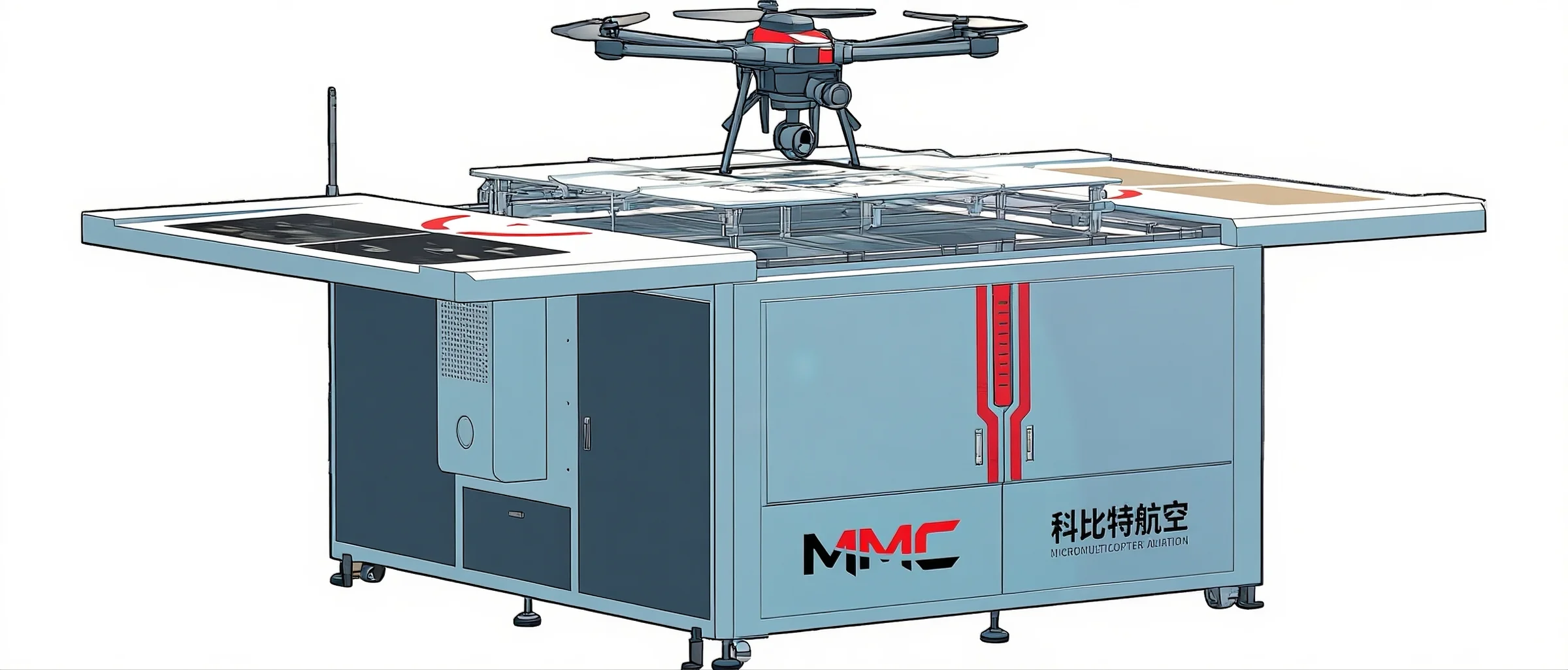
Skylle Ⅱ + hangar: Automated construction monitoring with scheduled flights, centimeter-precision data & 3D/DSM/Point Cloud outputs for progress tracking.
- Scheduled routine flights, autonomous hangar with charging/maintenance for 24/7 readiness.
- Centimeter-level precision via RTK/PPK (1.0cm+1ppm horizontal) & mechanical shutter.
- Multi-data outputs: 3D Models, DSM, DEM, Point Clouds & Orthomosaic Images.
- IP54, -20°C~65°C operation, 6-level wind resistance for harsh sites.
Drone Platform
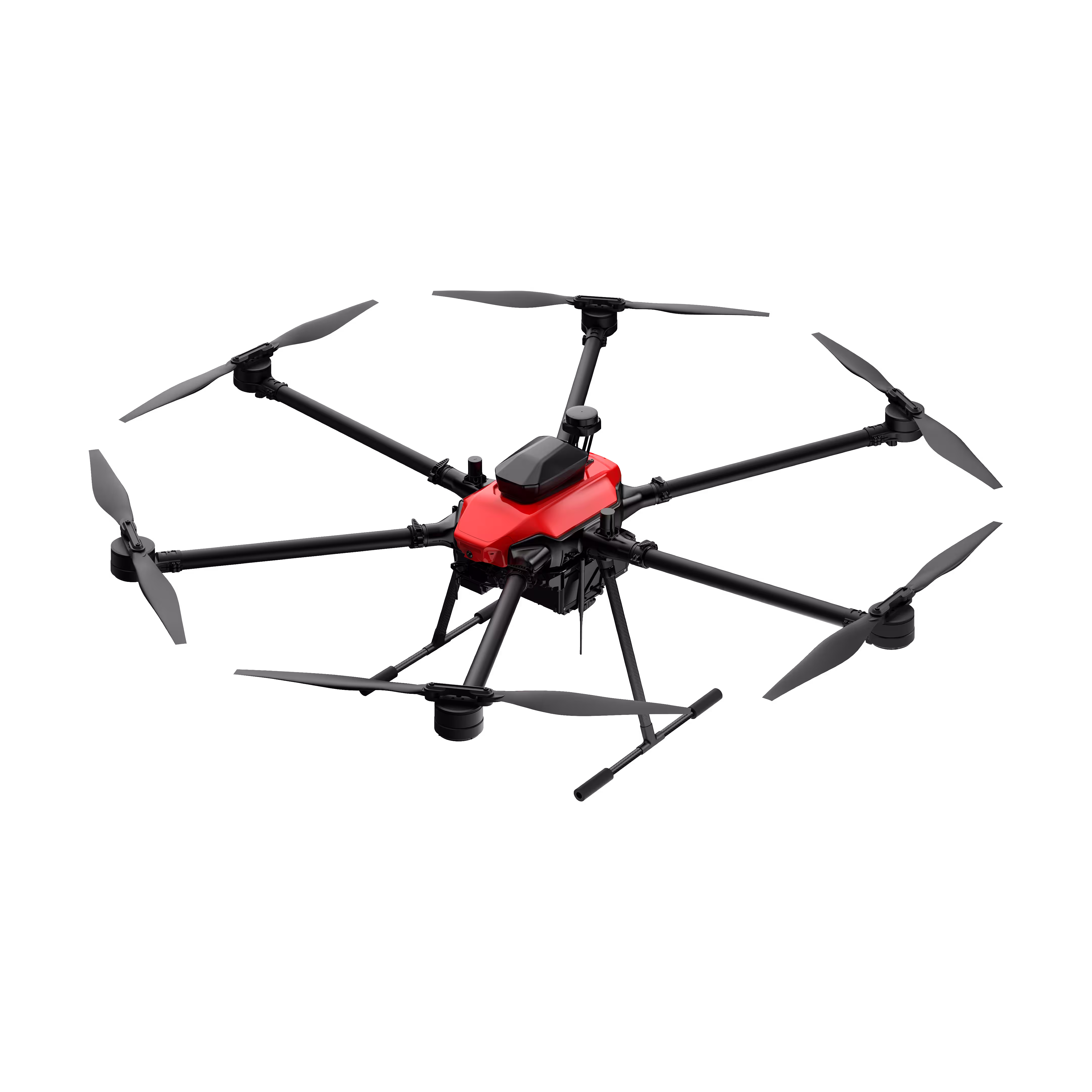
Skylle Ⅱ
Hexacopter Industrial Heavy-Lift Drone - 10kg Payload | 60min Flight Time | RTK cm-Level Positioning | IP54 Rated Read More
Learn MorePayload And Software
Skylle Ⅱ: Revolutionizing Construction Progress Management with Automated Site Monitoring
In the fast-paced world of construction, staying ahead of project timelines, ensuring precision, and minimizing delays are critical to success. Manual site inspections—time-consuming, error-prone, and resource-intensive—often fall short of meeting these demands. Enter the Skylle Ⅱ Automated Routine Construction Site Monitoring Solution, a game-changing integration of cutting-edge drone technology and intelligent hangar systems designed to redefine how construction progress is tracked, analyzed, and managed.
Unmatched Automation for Seamless Routine Monitoring
At the core of this solution is the Skylle Ⅱ hexacopter drone, engineered to deliver consistent, reliable data collection with minimal human intervention. Paired with its dedicated automated hangar, the system enables scheduled routine flights over construction sites, eliminating the need for manual deployment. Whether daily, weekly, or custom intervals, the Skylle Ⅱ autonomously takes off, executes pre-planned flight paths, captures critical data, and returns to the hangar for charging—all while you focus on decision-making, not logistics.
The hangar itself is a marvel of engineering: IP54-rated for all-weather resilience, it supports autonomous charging, battery hot-swapping, and payload maintenance, ensuring the Skylle Ⅱ is always mission-ready, even in harsh construction environments (-20°C to 65°C operating temperature). This seamless automation translates to uninterrupted data flow, keeping project stakeholders updated in real time.
Centimeter-Level Precision: The Foundation of Informed Decisions
Construction progress management demands accuracy—and the Skylle Ⅱ delivers with centimeter-level data precision, powered by its advanced RTK/PPK positioning system and high-performance mechanical shutter. With RTK horizontal accuracy of 1.0cm+1ppm and vertical accuracy of 1.5cm+1ppm, every measurement, from stockpile volumes to structural alignment, is captured with pinpoint precision.
This level of detail ensures that even the smallest deviations from plans are detected early, reducing rework costs and keeping projects on track. Whether verifying foundation levels or tracking structural steel installation, the Skylle Ⅱ turns raw data into actionable insights.
Multidimensional Data Outputs for Holistic Site Visibility
Beyond precision, the Skylle Ⅱ excels at transforming captured data into rich, actionable outputs tailored to construction needs. Its modular payload system supports high-resolution imaging and LiDAR sensors, generating:
- 3D Models: Detailed digital replicas of the site for clash detection and progress visualization.
- DSM/DEM: Digital Surface/ Elevation Models to analyze terrain changes and earthwork progress.
- Point Clouds: Dense 3D point datasets for volumetric calculations and structural analysis.
- Orthomosaic Images: High-resolution, georeferenced maps for area-wide progress tracking.
These outputs provide a comprehensive view of site conditions, enabling project managers to compare as-built status with BIM models, forecast material needs, and communicate progress to stakeholders with clarity.
Why Skylle Ⅱ? Built for the Rigors of Construction
- Heavy-Duty Performance: With a maximum payload of 10kg and 80-minute flight time (unmanned), the Skylle Ⅱ handles large sites and complex missions effortlessly.
- Rugged Reliability: Carbon fiber airframe, IP54 weather resistance, and 6-level wind tolerance ensure operations in dusty, rainy, or high-wind conditions.
- Smart Integration: Seamlessly connects with construction management software, allowing data to flow directly into BIM platforms, project scheduling tools, and stakeholder dashboards.
Transform Your Construction Site Management Today
The Skylle Ⅱ Automated Routine Construction Site Monitoring Solution isn’t just a tool—it’s a strategic asset. By automating data collection, ensuring centimeter-level precision, and delivering multidimensional insights, it empowers teams to:
✅ Reduce inspection time by up to 80% compared to manual surveys.
✅ Minimize costly rework with early detection of discrepancies.
✅ Enhance stakeholder communication with visual, data-driven progress reports.
Ready to elevate your construction progress management? Contact us today to see how Skylle Ⅱ can turn your site data into success.
Skylle Ⅱ: Where Automation Meets Precision—Building the Future, One Flight at a Time.
Portable Surveying & Mapping
Skylle Ⅱ + X4 Pro: Portable Surveying & Mapping for Construction Progress Management, with centimeter-level data & 3D/DSM/Point Cloud outputs to boost Progress Management efficiency.
- Portable, easy to operate & carry across sites, enabling flexible on-the-go Construction Progress Management.
- Centimeter-level data via mechanical shutter & RTK, ensuring precise Progress Management tracking of site details.
- Multi-outputs: 3D Models, DSM, DEM, Point Clouds, Orthomosaics for deep Progress Management insights.
- Simplifies Progress Management with intuitive operation, accelerating data-driven decisions in construction.
Drone Platform
Skylle Ⅱ
Hexacopter Industrial Heavy-Lift Drone - 10kg Payload | 60min Flight Time | RTK cm-Level Positioning | IP54 Rated Read More
Learn MorePayload And Software
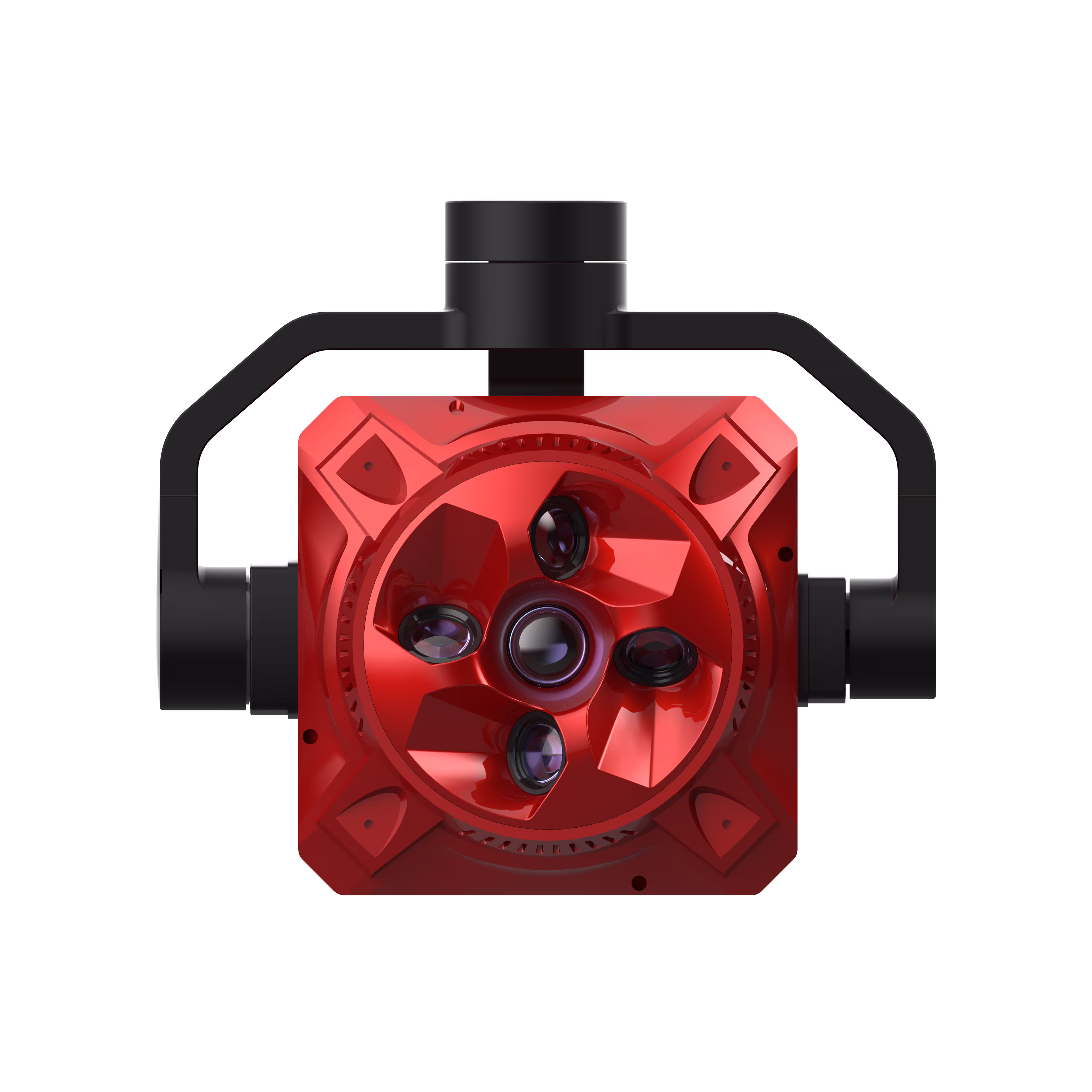
X4 Pro
MMC X4 Pro is a high-performance, multi-purpose aerial survey camera designed for 3D modeling and precision mapping. As a professional five-lens oblique photography system, it breaks through the limitations of traditional single-angle mapping cameras, providing an integrated, high-precision, and efficient aerial survey solution for various mapping scenarios. Read More
Learn MoreSkylle Ⅱ + X4 Pro: Portable Surveying & Mapping Redefining Construction Progress Management
In construction, effective Progress Management hinges on timely, accurate data—and traditional surveying tools often fall short, slowing decision-making and delaying project milestones. Introducing the Skylle Ⅱ + X4 Pro Portable Surveying & Mapping Solution—a lightweight, high-performance duo engineered to streamline Progress Management across dynamic construction sites.
Portable by Design: Adapt to Every Site
Designed for the demands of multi-site Progress Management, this solution prioritizes portability without compromising power. The Skylle Ⅱ drone, weighing just 12kg (with battery), and the X4 Pro 5-lens camera (≤900g) pack professional-grade capabilities into a backpack-friendly setup. No heavy equipment, no complex logistics—assemble in 10 minutes, launch from tight spaces, and seamlessly transition between sites. Whether tracking foundation work at Site A or structural framing at Site B, this portability ensures Progress Management never stalls, keeping teams aligned and projects on schedule.
Centimeter-Level Precision
Progress Management thrives on accuracy, and the Skylle Ⅱ + X4 Pro delivers with centimeter-level data . Skylle Ⅱ’s RTK module (1.0cm horizontal accuracy) and X4 Pro’s mechanical shutter eliminate motion blur, capturing geotagged details critical for Progress Management—from stockpile volumes to structural alignment checks. When every centimeter matters, this precision ensures Progress Management decisions are rooted in facts, reducing rework and keeping projects on track.
Multi-Dimensional Data: Elevate Progress Management Insights
To drive Progress Management, you need more than just images—you need actionable data. The X4 Pro’s 5-lens array (total 220MP pixels) generates outputs tailored for Progress Management: 3D Models for as-built vs. BIM comparisons, DSM/DEM for terrain progress tracking, Point Clouds for volumetric calculations, and Orthomosaics for site-wide progress visualization. These tools transform raw data into Progress Management dashboards, letting stakeholders spot delays, verify milestones, and adjust plans in real time.
Progress Management Simplified: Intuitive Operation for Every Team
Progress Management shouldn’t require expert training. The Skylle Ⅱ + X4 Pro integrates with user-friendly flight apps, enabling one-person operation—no drone license needed. Pre-programmed flight paths automate data capture, while the X4 Pro’s plug-and-play storage (600MB/s transfer speed) ensures Progress Management data is instantly accessible for analysis. This simplicity empowers on-site teams to take ownership of Progress Management, reducing reliance on external surveyors and accelerating data-to-decision cycles.
Accelerate Progress Management—Anywhere, Anytime
The Skylle Ⅱ + X4 Pro isn’t just a tool; it’s a Progress Management partner. Portable, precise, and data-rich, it equips teams to track progress in real time, mitigate risks early, and keep projects moving forward.
Ready to transform your construction Progress Management? Deploy the Skylle Ⅱ + X4 Pro today—and build smarter, faster, with confidence.
Skylle Ⅱ + X4 Pro: Portable Power for Progress Management Excellence.