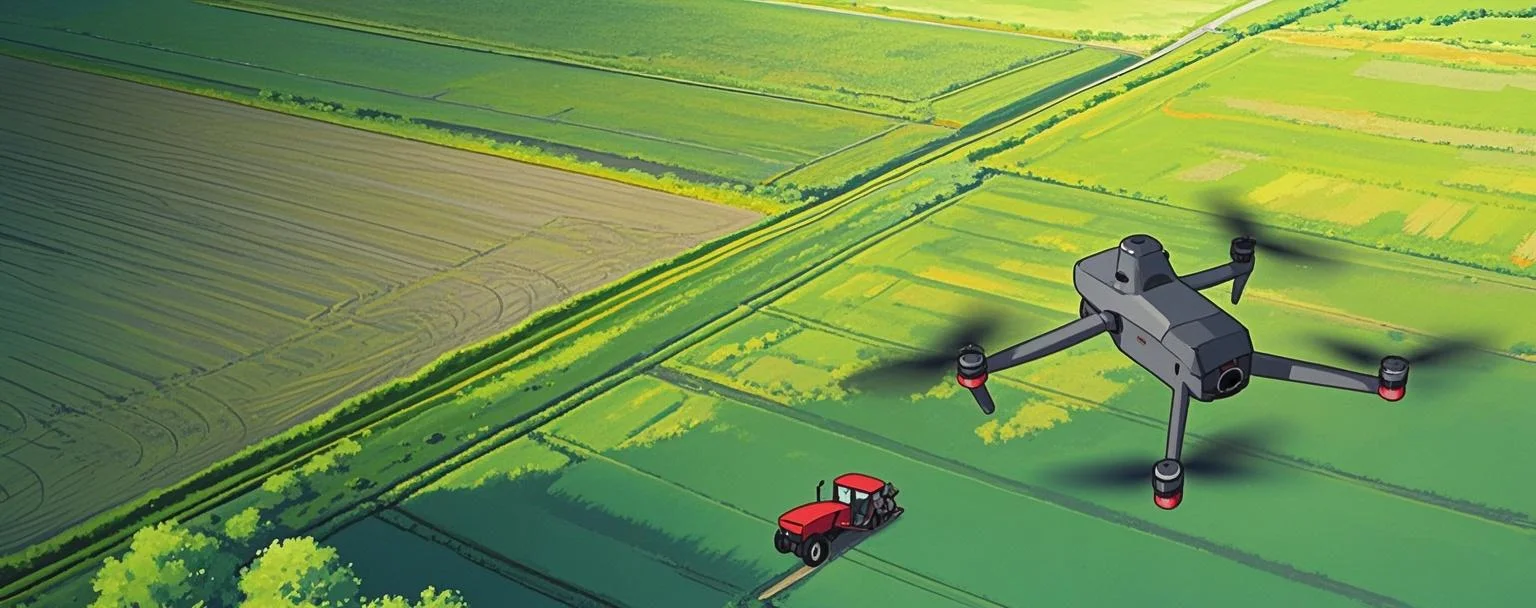
Precision Agriculture
MMC precision agriculture solutions transform farm management through intelligent aerial monitoring. Our drone systems enable rapid field scanning with multispectral sensors to assess crop health, soil conditions, and irrigation needs. The technology identifies disease outbreaks and nutrient deficiencies early, allowing targeted treatment that reduces chemical use by up to 30%. Automated data processing delivers actionable insights within hours, helping farmers optimize yields while cutting operational costs. Ideal for large-scale row crops, orchards, and vineyards.
Painpoints
- – It's difficult to accurately locate the crop areas that need attention without geotaged data.
- – Manual samplings are lengthy and labor consuming, thus reducing the possible sampling frequency.
- – Traditional crop evaluation methods rely on observation with limited data analysis.
- – Limited visibility of the crop field overall health.
Advantages
- Evaluate health and prevent diseases of each invidual crop with georeference data collection.
- Increase data sampling frequency with fast aerial data collection.
- Access a variety of data including RGB images, multispectral, thermal, and LiDAR data.
- Cover larger areas in a single flight.
Solution
Portable Mapping & Stand Count Analysis
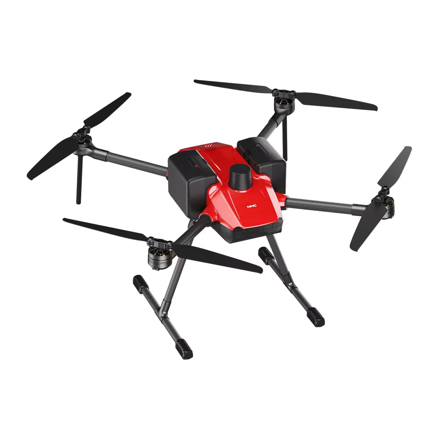
Notuzi Ⅲ + MMC X2C: Portable mapping & stand count solution with centimeter-level data via RTK & mechanical shutter.
- Portable design: Lightweight, foldable drone fits backpack for easy transport across multiple farms/fields.
- Centimeter-level accuracy: Mechanical shutter & RTK deliver precise data.
- Simplified stand count: Auto-generates reports/maps in 10 mins, streamlining workflows.
- Field-ready durability: IP54-rated, 45-min flight, hot-swappable batteries for all-day use.
Drone Platform
Notuzi S
Professional-grade UAV designed for versatile industrial applications, catering to sectors such as power inspection, public security, energy, and firefighting. Read More
Learn MorePayload And Software
X2C
A professional aerial survey camera designed for 3D modeling, capturing multi-angle spatial images to deliver realistic terrain/texture details for topographic, real estate, and architectural mapping. Read More
Learn MoreNotuzi Ⅲ + MMC X2C: Redefine Precision Agriculture with Portable Mapping & Stand Count Mastery
In the fast-evolving world of precision agriculture, farmers and agronomists need tools that blend mobility, accuracy, and simplicity to unlock field potential. Enter the Portable Mapping & Stand Count Analysis Solution: Notuzi Ⅲ paired with MMC X2C—engineered to empower precision agriculture with data-driven insights, anywhere your fields take you.
Portable by Design
Precision agriculture thrives on adaptability, and Notuzi Ⅲ delivers. Weighing just 3.6kg with a foldable carbon-fiber frame, this drone fits into a backpack, ready to deploy across multiple farms, remote fields, or rolling landscapes in minutes. No bulky setups or specialized training required: its intuitive 7-inch touchscreen controller and one-tap mission planning let users map fields or count stands effortlessly. For precision agriculture professionals juggling diverse plots, portability isn’t a luxury—it’s a necessity, and Notuzi Ⅲ delivers.
Centimeter-Level Accuracy
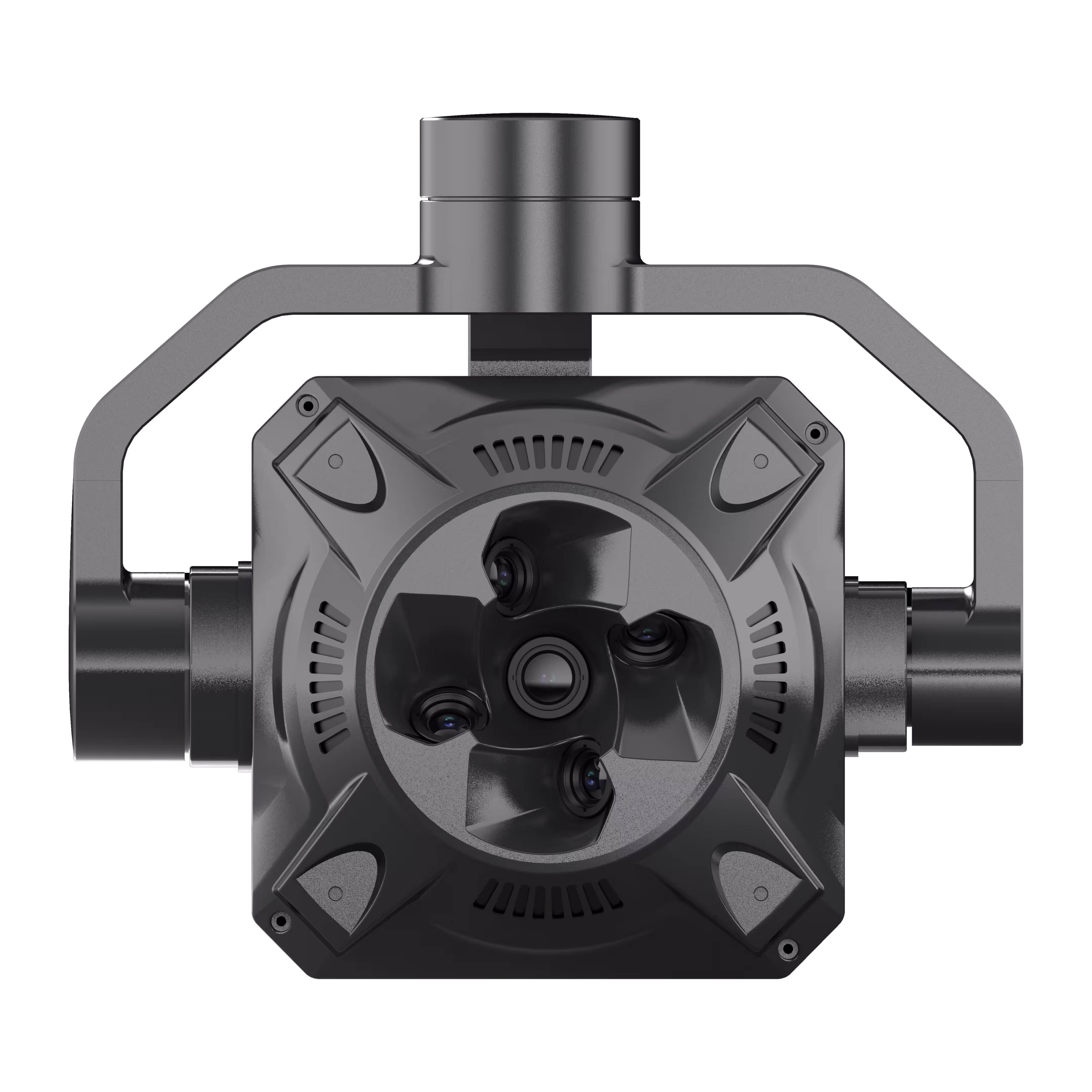
At the core of this solution lies MMC X2C, a 6-lens mapping payload built for precision agriculture’s most demanding tasks. Equipped with a mechanical shutter to eliminate motion blur and RTK (Real-Time Kinematic) positioning, it captures data with centimeter-level precision—critical for stand count analysis, crop health mapping, and yield prediction. Whether measuring plant spacing, tracking growth stages, or identifying underperforming zones, MMC X2C turns raw images into actionable insights that drive smarter, more efficient precision agriculture decisions.
Simplify Stand Count Analysis
Gone are the days of manual stand counting or delayed data processing. Notuzi Ⅲ + MMC X2C integrates with agronomic software to auto-generate stand count reports, plant density maps, and growth trend analyses within 10 minutes of flight. This speed transforms how farmers manage crops: adjust seeding rates, target fertilizer applications, or flag stress zones early—all powered by the precision agriculture data that matters most.
Built for the Field
Precision agriculture doesn’t stop for dust, rain, or extreme temperatures—and neither does this solution. Notuzi Ⅲ’s IP54-rated body resists harsh elements, while MMC X2C’s ruggedized lens housing protects sensors during transport. With a 45-minute flight time and hot-swappable batteries, you can map 200+ acres in a single day, ensuring precision agriculture stays productive from dawn till dusk.
Precision Agriculture, Delivered Where It Counts
From small family farms to large agribusinesses, Notuzi Ⅲ + MMC X2C redefines precision agriculture. Portable enough to follow the harvest, accurate enough to guide every seed, and simple enough to use daily—this isn’t just a tool. It’s a partner in growing the future of precision agriculture, one field, one stand, one centimeter at a time.
Ready to Grow Smarter?
Elevate your precision agriculture with Notuzi Ⅲ + MMC X2C. Portable, precise, and powerful—because your fields deserve nothing less.
Portable Multispectral Data Collection
Notuzi Ⅲ + MMC X2C: Portable multispectral data collection for precision agriculture—cm-level data, vegetation health, prescription maps via RTK/mechanical shutter.
- Portable & easy: Lightweight, foldable design for easy carry/operation across multiple farms/fields.
- cm-level accuracy: Mechanical shutter + RTK deliver precise data.
- Vegetation health: Multispectral sensors assess crop stress (NDVI/NDRE) for targeted care.
- Prescription maps: MMC X2C auto-generates maps to guide variable-rate input applications.
Drone Platform
Notuzi S
Professional-grade UAV designed for versatile industrial applications, catering to sectors such as power inspection, public security, energy, and firefighting. Read More
Learn MorePayload And Software
X2C
A professional aerial survey camera designed for 3D modeling, capturing multi-angle spatial images to deliver realistic terrain/texture details for topographic, real estate, and architectural mapping. Read More
Learn MoreNotuzi Ⅲ + MMC X2C – Portable Multispectral Data Collection for Smarter Farms
In the dynamic world of precision agriculture, farmers and agronomists need tools that keep pace with the demands of modern farming—tools that are portable, precise, and powerful enough to turn data into decisions. Introducing the Portable Multispectral Data Collection Solution: Notuzi Ⅲ paired with MMC X2C. This game-changing duo is engineered to redefine precision agriculture, making multispectral data collection, vegetation health assessment, and prescription map generation accessible, efficient, and indispensable for every farm.
Portable by Design
Precision agriculture thrives on adaptability, and Notuzi Ⅲ leads the charge. Weighing just 3.8kg with a foldable carbon-fiber frame, this drone slips into a backpack, ready to deploy across multiple farms, remote fields, or rolling landscapes in minutes. No bulky equipment, no complicated setups—simply unfold, power on, and fly. Its intuitive 7-inch touchscreen controller and one-touch mission planning let even first-time users collect multispectral data without training, making precision agriculture accessible to every operation, big or small. For farmers juggling diverse plots, portability isn’t just convenience—it’s the key to scaling precision agriculture across your entire operation.
Centimeter-Level Accuracy
At the heart of this solution lies MMC X2C, a multispectral payload built for precision agriculture’s most critical demands. Equipped with a mechanical shutter to eliminate motion blur and RTK (Real-Time Kinematic) positioning, it captures data with centimeter-level precision—the gold standard for precision agriculture. Whether mapping field boundaries, tracking crop growth stages, or measuring plant spacing, MMC X2C ensures every data point is accurate, reliable, and actionable. In precision agriculture, where decisions hinge on details, this level of accuracy transforms guesswork into certainty.
Vegetation Health Assessment: Multispectral Insights
Healthy crops are the backbone of successful precision agriculture, and MMC X2C’s multispectral sensors deliver the insights to protect them. With 5 dedicated spectral bands (400–1000nm), including NIR, red, and green, it captures critical vegetation indices like NDVI (Normalized Difference Vegetation Index), NDRE (Normalized Difference Red Edge), and chlorophyll content. These metrics reveal hidden stress—drought, nutrient deficiencies, or pest infestations—before they’re visible to the naked eye. By identifying problem areas early, you can target interventions, reduce waste, and maximize yields—all hallmarks of precision agriculture done right.
Prescription Map Generation: Turn Data into Action
Data collection is just the first step; precision agriculture demands action. MMC X2C integrates seamlessly with MMC’s agronomic software suite to auto-generate prescription maps—detailed, field-specific plans for fertilization, irrigation, or pest control. These maps sync directly with farm machinery, guiding variable-rate applications that deliver resources exactly where crops need them. No more blanket treatments, no more wasted inputs—just targeted, efficient management that cuts costs and boosts sustainability. In precision agriculture, prescription maps turn data into dollars, making every drop of water or gram of fertilizer count.
Why Notuzi Ⅲ + MMC X2C?
Precision agriculture isn’t just about technology—it’s about trust. Notuzi Ⅲ’s rugged IP54-rated body withstands dust, rain, and temperatures from -20°C to 65°C, ensuring reliable flights even in harsh farm conditions. MMC X2C’s hot-swappable battery and 45-minute flight time let you cover 200+ acres in a single day, keeping precision agriculture productive from dawn till dusk. Together, they create a solution that doesn’t just support precision agriculture—it elevates it, making every farm smarter, more efficient, and more profitable.
Join the Precision Agriculture Revolution
From small family farms to large agribusinesses, Notuzi Ⅲ + MMC X2C is the partner precision agriculture deserves. Portable enough to follow the harvest, accurate enough to guide every seed, and powerful enough to transform data into decisions—this isn’t just a tool. It’s the future of precision agriculture, growing healthier crops, higher yields, and more sustainable farms, one field at a time.
Ready to Grow Smarter?
Elevate your precision agriculture with Notuzi Ⅲ + MMC X2C. Portable, precise, and purpose-built for your farm.

Precise Visual Vegetation Analysis
Skylle Ⅱ + X4 Pro: Precision agriculture solution with 3 km²/flight, 5cm GSD, 45MP full-frame sensor for intelligent disease detection.
- Field efficiency: Covers 3 km²/flight with 5cm GSD, maximizing workflow speed.
- Rugged reliability: Multi-purpose drone platform endures harsh environments for consistent data collection.
- 45MP full-frame: High-res sensor captures detailed vegetation data critical for health analysis.
- Disease detection: Enables intelligent model-driven disease identification via high-resolution imagery.
Drone Platform
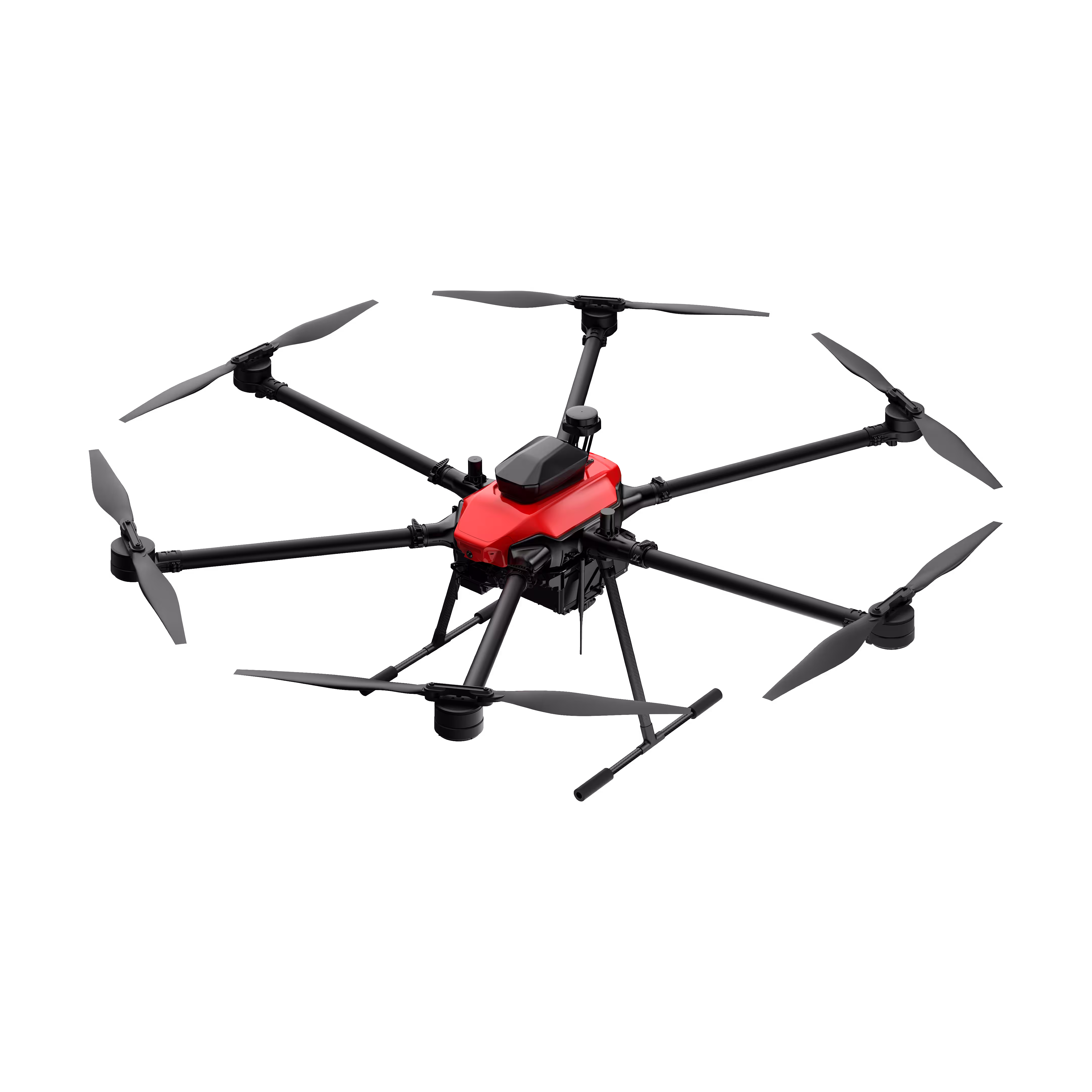
Skylle Ⅱ
Hexacopter Industrial Heavy-Lift Drone - 10kg Payload | 60min Flight Time | RTK cm-Level Positioning | IP54 Rated Read More
Learn MorePayload And Software
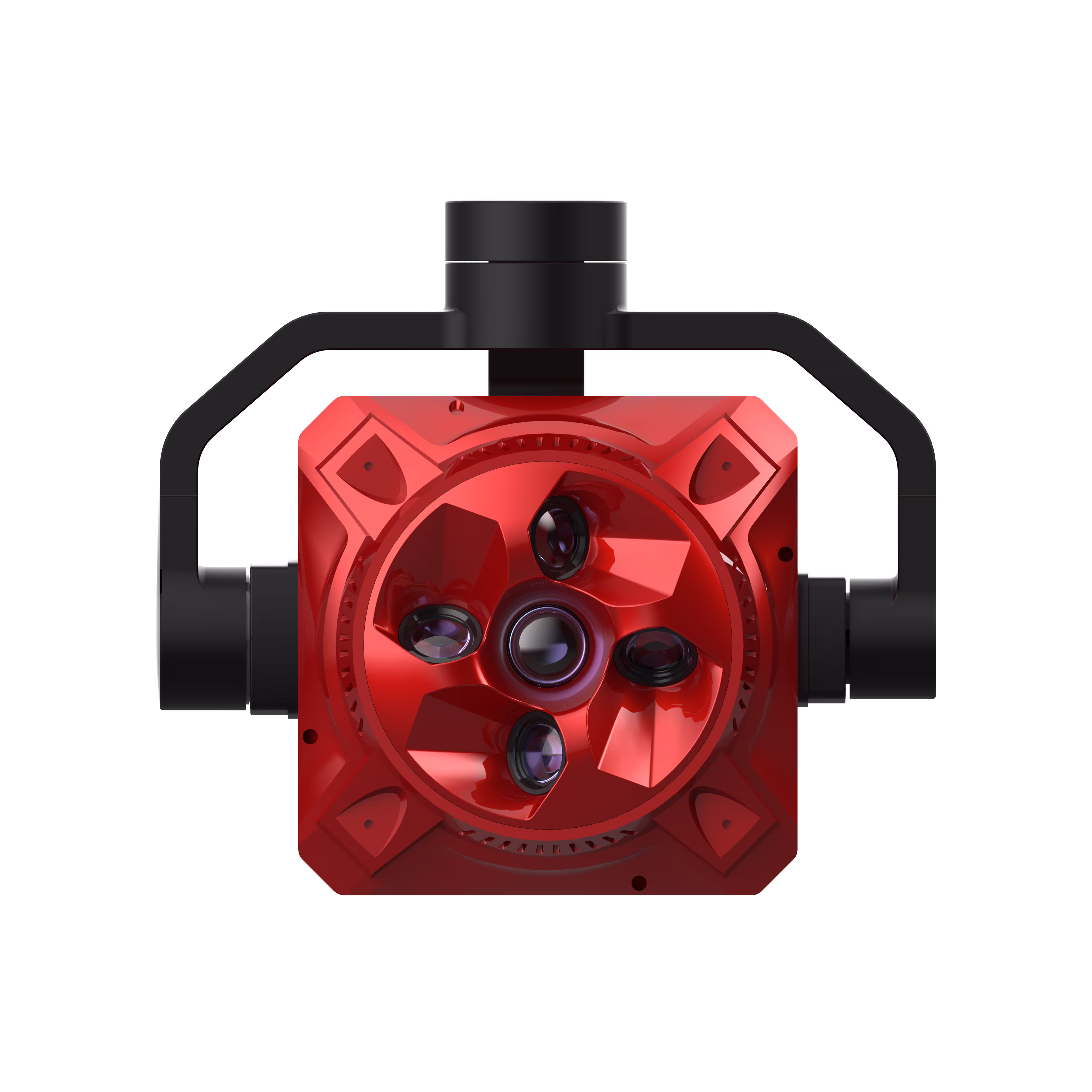
X4 Pro
MMC X4 Pro is a high-performance, multi-purpose aerial survey camera designed for 3D modeling and precision mapping. As a professional five-lens oblique photography system, it breaks through the limitations of traditional single-angle mapping cameras, providing an integrated, high-precision, and efficient aerial survey solution for various mapping scenarios. Read More
Learn MoreSkylle Ⅱ + X4 Pro – Precise Visual Vegetation Analysis for Smarter Crop Health
In precision agriculture, every square meter of data and every early disease signal matters. Farmers and agronomists need tools that deliver efficiency, durability, and unmatched clarity to turn field insights into actionable decisions. Introducing the Precise Visual Vegetation Analysis Solution: Skylle Ⅱ drone paired with X4 Pro camera—engineered to redefine precision agriculture with field-leading efficiency, rugged reliability, and ultra-high-resolution data.
Unmatched Field-Work Efficiency: 3 km² per Flight, 5cm GSD
Precision agriculture thrives on speed without sacrificing detail, and Skylle Ⅱ delivers. With a 45-minute flight time and optimized flight planning, it covers 3 km² per flight—enough to map an entire farm in a single morning. Paired with X4 Pro’s advanced imaging, it captures data at 5cm Ground Sampling Distance (GSD)—so precise, you can distinguish individual leaves, stalks, or even pest damage. No more time wasted on multiple flights; just comprehensive, high-resolution coverage to drive precision agriculture forward.
Rugged Reliability: Built to Endure Harsh Agricultural Environments
Precision agriculture doesn’t stop for dust, rain, or extreme temperatures—and neither does Skylle Ⅱ. This multi-purpose drone platform is engineered with an IP55-rated airframe, reinforced landing gear, and a weather-sealed design to withstand -20°C to 60°C temperatures, high winds, and heavy dust. Whether in arid plains, humid orchards, or storm-prone valleys, Skylle Ⅱ ensures consistent, uninterrupted data collection, making it the backbone of reliable precision agriculture.
45MP Full-Frame Sensor: Ultra-High-Definition Data
At the core of this solution lies X4 Pro’s 45MP full-frame sensor—a game-changer for precision agriculture. Its large sensor captures richer detail, vibrant colors, and finer texture, ensuring no subtle crop stressor goes unnoticed. From chlorophyll levels to leaf structure, the high-quality data fuels accurate vegetation indices (NDVI, NDRE) and sets the stage for deep crop health analysis. Clarity isn’t optional—it’s essential, and X4 Pro delivers.
Intelligent Disease Detection: High-Resolution Imagery for Model-Driven Insights
Beyond data collection, this solution empowers intelligent model-driven disease detection. X4 Pro’s high-resolution imagery, combined with AI-powered analytics platforms, identifies early signs of crop diseases, nutrient deficiencies, or pest infestations—often before visual symptoms appear. By flagging hotspots with pinpoint accuracy, farmers can target interventions, reduce chemical use, and protect yields. Proactive detection isn’t just smart—it’s profitable.
Why Skylle Ⅱ + X4 Pro?
Precision agriculture demands tools that work as hard as you do. Skylle Ⅱ’s efficiency maximizes field time, its ruggedness ensures reliability, and X4 Pro’s sensor captures the detail that matters. Together, they transform raw data into actionable insights, making precision agriculture more accessible, effective, and impactful than ever before.
Transform Your Fields with Precision
From smallholder farms to large agribusinesses, Skylle Ⅱ + X4 Pro is the precision agriculture solution you’ve been waiting for. Efficient, durable, and intelligent—this isn’t just technology. It’s the future of precision agriculture, growing healthier crops, higher yields, and more sustainable farms, one high-resolution image at a time.
Ready to Grow Smarter?
Elevate your precision agriculture with Skylle Ⅱ + X4 Pro. Precision, efficiency, and intelligence—delivered.