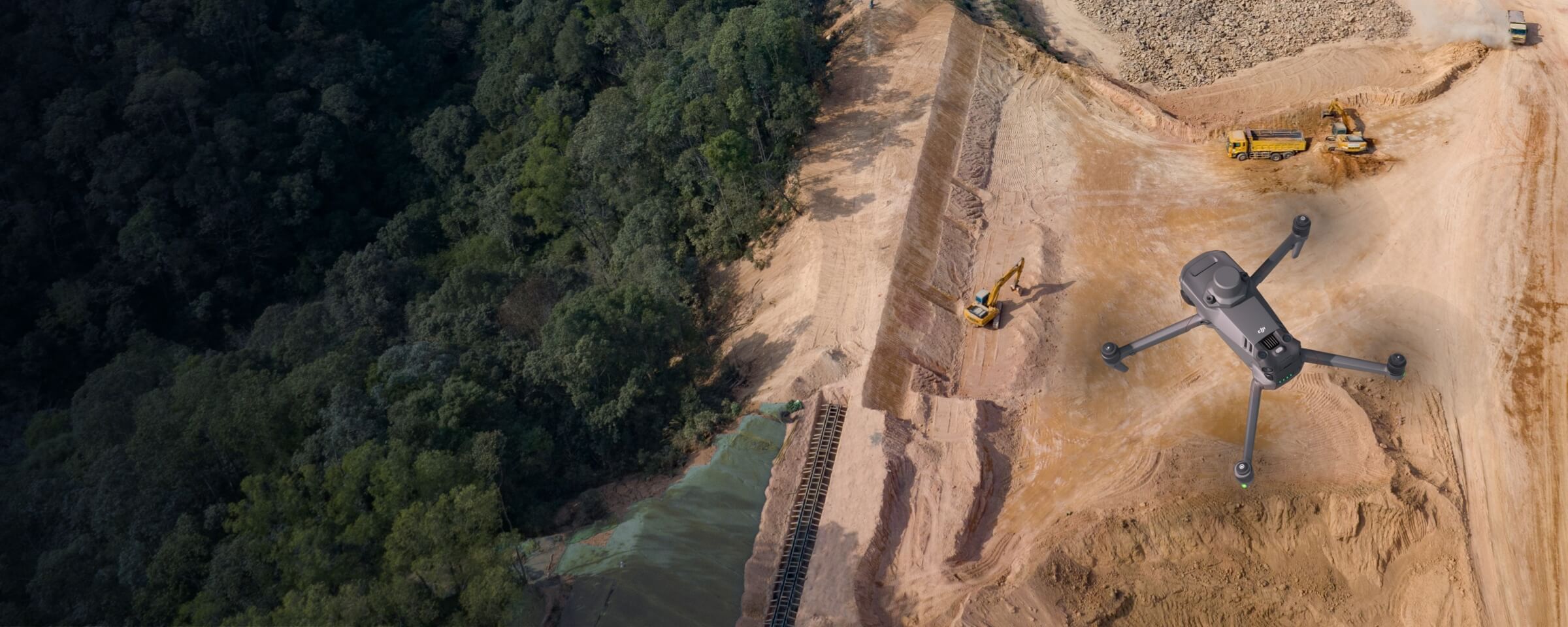
Earthwork
MMC Drones' Earthwork Solutions optimize excavation, grading, and material management with precise aerial data. Our drone-powered systems automate volume measurements of earth movements and stockpiles, delivering centimeter-accurate calculations up to 5x faster than manual surveys. Frequent flyovers track progress against designs, minimize over-excavation, and prevent costly rework—ensuring projects stay on budget and schedule.
Painpoints
- – Absence of frequently updated stockpile measurements can lead to project delays and inaccurate resources supply.
- – Inefficient walk-based methods results on higher labor cost and time.
- – Stockpile manual measurements accuracy can be compromised by human errors.
Advantages
- Generate updated Stockpile Measurement with Point Cloud Data at any time.
- Cut field work time with efficient drone-based data collection.
- Ensure data quality and consistency with repeatable mission flights.
Solution
Portable Drone Surveying & Mapping Solution
Skylle Ⅱ + MMC X2C: Portable drone solution for construction earthwork—centimeter precision, multi-data outputs (3D models, DSM, DEM, point clouds) for efficient monitoring.
- Ultra-portable: Carbon fiber drone, quick-release design, lightweight camera—easy transport across sites.
- Centimeter accuracy: RTK positioning, mechanical shutter—reliable data for earthwork measurements.
- Multi-data outputs: 3D models, DSM, DEM, point clouds—optimize progress tracking.
- Easy operation: Autonomous flight, quick setup—unpack and fly in minutes for efficient surveys.
Drone Platform
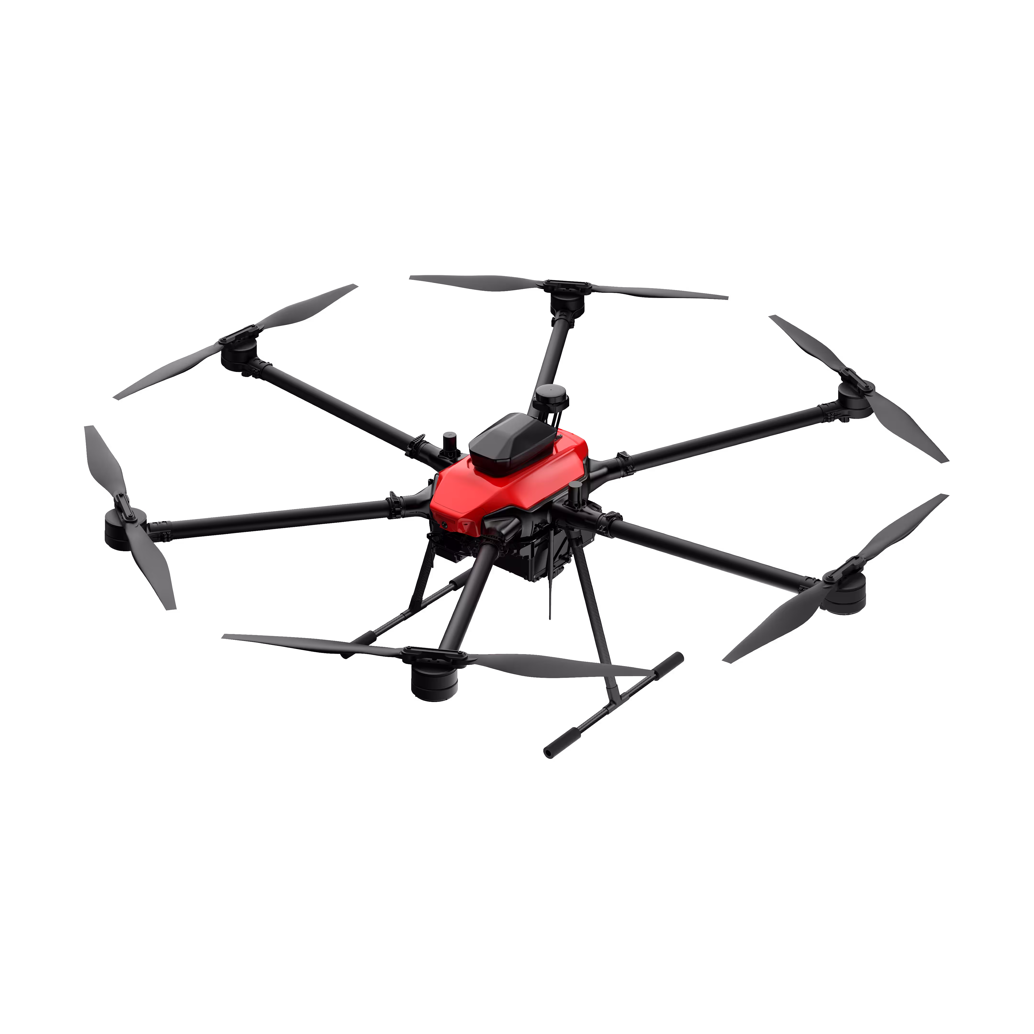
Skylle Ⅱ
Hexacopter Industrial Heavy-Lift Drone - 10kg Payload | 60min Flight Time | RTK cm-Level Positioning | IP54 Rated Read More
Learn MorePayload And Software
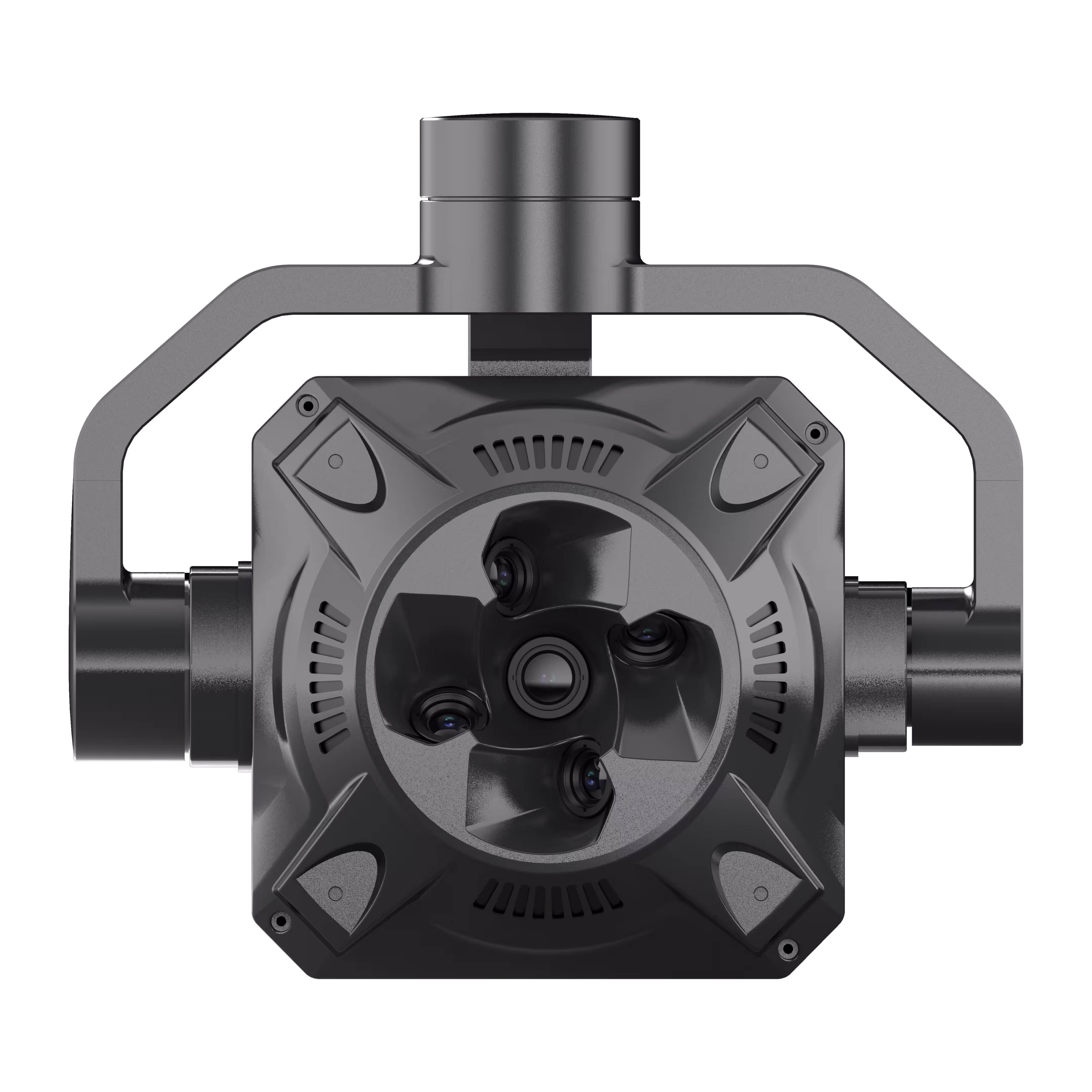
X2C
A professional aerial survey camera designed for 3D modeling, capturing multi-angle spatial images to deliver realistic terrain/texture details for topographic, real estate, and architectural mapping. Read More
Learn MoreSkylle Ⅱ + MMC X2C: Revolutionize Earthwork Surveying with Portable, Precision Drone Solutions
In construction, earthwork monitoring demands speed, accuracy, and adaptability. Traditional land surveying—slow, labor-heavy, and prone to errors—often delays decisions and inflates costs. Introducing the Skylle Ⅱ Portable Drone Surveying & Mapping Solution, paired with the MMC X2C 5-Lens Photogrammetry Camera. Built for construction teams, this integrated system delivers centimeter-level data, multi-dimensional outputs, and unmatched portability—transforming how you track cut/fill volumes, validate terrain, and accelerate earthwork progress.
Why Skylle Ⅱ + MMC X2C? Built for Earthwork, Engineered for Results
1. Ultra-Portable: Move Swiftly Across Job Sites
Skylle Ⅱ’s carbon fiber one-piece frame (17.2kg empty weight) and quick-release arms fold compactly, fitting into a portable case for easy transport between sites. The MMC X2C camera, at just 1.1kg with a rugged aluminum body, mounts seamlessly—so your entire survey kit is backpack-ready. Unpack, assemble, and fly in 5 minutes: no heavy equipment, no complex setups.
2. Centimeter-Level Precision: Trust Every Measurement
Earthwork accuracy starts with data you can rely on. Skylle Ⅱ’s RTK positioning and MMC X2C’s mechanical shutter (S-GS global shutter) eliminate motion blur and geotag errors, capturing imagery with centimeter-level precision. MMC X2C’s 5-lens system (1 vertical + 4 oblique) synchronizes high-resolution data capture, while real-time POS offset calculation ensures 5-way precise location data—critical for validating cut/fill volumes and terrain models.
3. Multi-Data Outputs: Monitor Earthwork Efficiently
From raw data to actionable insights, the solution delivers everything you need:
- 3D Models & Point Clouds: Detailed terrain reconstructions for volume calculations and progress tracking.
- DSM/DEM: Digital Surface/Elevation Models to analyze slope stability and drainage.
MMC X2C’s intuitive software auto-generates outputs, cutting post-processing time by 60%—so you get results faster, adjust plans sooner.
4. Built for the Field: Durable, Reliable, All-Weather
Construction sites are tough—but Skylle Ⅱ + MMC X2C thrive. Skylle Ⅱ’s IP54 rating resists dust/rain, while dual backup batteries provide 80 minutes of flight to cover 100+ acres per mission. MMC X2C operates in -20°C~65°C, with a metal frame and no exposed cables—ensuring reliability in dirt, wind, or extreme temperatures.
Earthwork Reimagined: Faster, Smarter, More Profitable
With Skylle Ⅱ and MMC X2C, earthwork surveying moves from a bottleneck to a competitive edge. Whether you’re tracking daily cut/fill, validating design vs. as-built, or updating stakeholders, this solution lets you:
✅ Slash survey time by 70% vs. traditional methods.
✅ Reduce rework with centimeter-accurate volume data.
✅ Streamline reporting with auto-generated 3D models and DSM/DEM.
Ready to Transform Your Earthwork Workflow?
Skylle Ⅱ + MMC X2C isn’t just a tool—it’s your partner in delivering projects on time, on budget, and with precision. Contact us today to demo the solution and see how portable drone surveying elevates your construction site monitoring.
Skylle Ⅱ Drone | MMC X2C 5-Lens Camera | Built for Earthwork. Built for Accuracy.
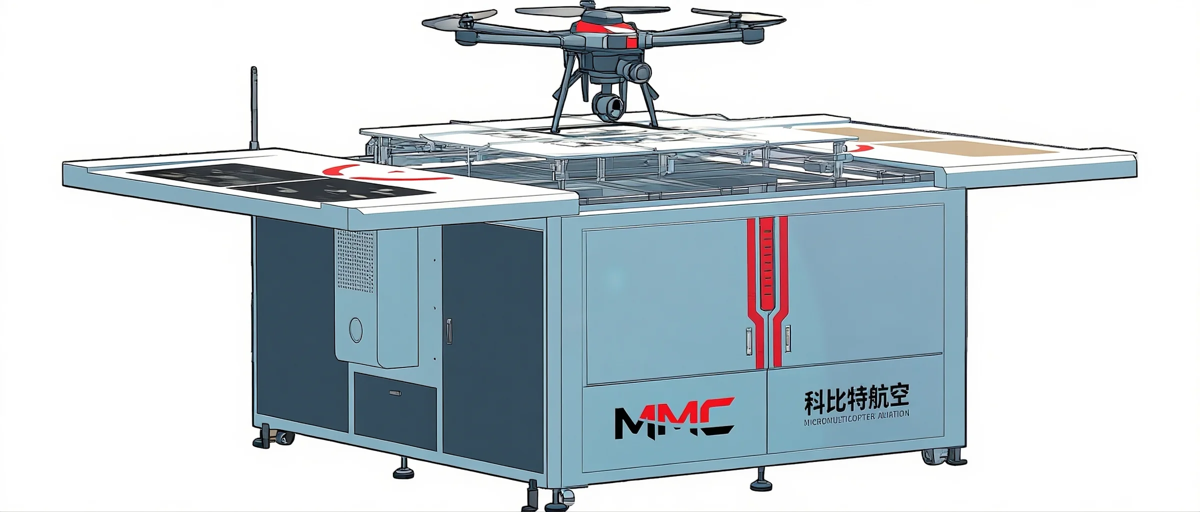
Automated Routine Stockpile Measurement Solution
Skylle Ⅱ Hangar + MMC X2C: Automated routine stockpile measurement for construction—centimeter precision, 3D models/DSM/point clouds, MMC cloud collaboration.
- Scheduled flights: Automate routine data collection for frequent centimeter-level earthwork measurement.
- Accurate outputs: 3D models, DSM, point clouds for precise stockpile volume analysis and monitoring.
- MMC cloud collaboration: Auto-upload data for cross-team access to real-time insights and shared analysis.
- 24/7 automation: Dedicated hangar enables uninterrupted operations, reducing manual effort in surveys.
Drone Platform
Skylle Ⅱ
Hexacopter Industrial Heavy-Lift Drone - 10kg Payload | 60min Flight Time | RTK cm-Level Positioning | IP54 Rated Read More
Learn MorePayload And Software
X2C
A professional aerial survey camera designed for 3D modeling, capturing multi-angle spatial images to deliver realistic terrain/texture details for topographic, real estate, and architectural mapping. Read More
Learn MoreSkylle Ⅱ Hangar Edition + MMC X2C: Automate Stockpile Measurement, Redefine Earthwork Efficiency
In construction, stockpile monitoring demands consistency, precision, and collaboration. Manual surveys or ad-hoc drone flights often result in delayed data, human error, and siloed insights—slowing decisions and inflating costs. Introducing the Skylle Ⅱ Hangar-Based Automated Surveying Solution, paired with the MMC X2C 5-Lens Photogrammetry Camera and Skylle Ⅱ’s dedicated hangar. This all-in-one system automates routine flights, delivers centimeter-level data, and streams insights to MMC’s cloud platform—empowering your team to track stockpiles, validate volumes, and collaborate seamlessly, 24/7.
Why Skylle Ⅱ Hangar Edition + MMC X2C? Built for Automation, Engineered for Collaboration
1. Schedule & Forget: Routine Flights, Zero Manual Effort
Tired of coordinating surveyors for weekly stockpile checks? Skylle Ⅱ’s dedicated hangar enables fully automated mission scheduling—set daily, weekly, or custom flight plans, and the system handles takeoff, data capture, landing, and charging autonomously. Equipped with RTK+visual precision landing (≤30cm error), Skylle Ⅱ returns to the hangar reliably, even in harsh weather. Focus on analysis, not logistics: your stockpile data is collected without human intervention.
2. Centimeter-Level Accuracy: Trust Every Stockpile Volume
Stockpile measurements demand precision—and Skylle Ⅱ + MMC X2C deliver. Skylle Ⅱ’s RTK positioning and MMC X2C’s mechanical shutter eliminate motion blur, ensuring geotagged imagery with centimeter-level accuracy. MMC X2C’s 5-lens system (1 vertical + 4 oblique) captures synchronized high-resolution data, generating dense point clouds and 3D models that precisely calculate cut/fill volumes. Whether tracking aggregates, soil, or materials, you’ll get data you can stake your project on.
3. Multi-Data Outputs: Streamline Earthwork Monitoring
From raw data to actionable insights, the solution generates everything your team needs:
- 3D Models & Point Clouds: Detailed stockpile reconstructions for volume validation and progress tracking.
- DSM (Digital Surface Models): Elevation data to analyze terrain changes and slope stability.
MMC X2C’s onboard processing auto-generates outputs, while the hangar’s 4G/5G connectivity uploads data instantly—so you spend less time processing, more time decision-making.
4. MMC Cloud Collaboration: Unite Teams, Accelerate Decisions
Data is only powerful if shared. Collected survey data auto-uploads to MMC’s cloud platform, where engineers, project managers, and stakeholders access real-time 3D models, volume reports, and trend analyses from any device. Annotate findings, compare datasets over time, and align on next steps—no more emailing large files or waiting for in-person meetings. Cross-team collaboration, simplified.
Built for the Field: Durable, All-Weather, Uninterrupted
Construction sites don’t stop for weather—and neither does your surveying. Skylle Ⅱ’s IP54 rating resists dust and rain, while the hangar’s temperature control (-20°C~65°C) and UPS backup power ensure operations in extreme conditions. MMC X2C’s rugged metal frame and enclosed design stand up to vibrations and debris, delivering consistent data every flight.
Automate, Collaborate, Succeed: Transform Stockpile Management Today
Skylle Ⅱ Hangar Edition + MMC X2C isn’t just a tool—it’s your 24/7 stockpile surveying partner. With automated flights, centimeter precision, and cloud collaboration, you’ll:
✅ Cut survey time by 90% vs. manual methods.
✅ Reduce rework with accurate, real-time volume data.
✅ Align teams with shared access to MMC’s cloud platform.
Ready to Automate Your Earthwork Insights?
Skylle Ⅱ Hangar Edition + MMC X2C transforms stockpile measurement from a chore to a strategic advantage. Contact us to schedule a demo and see how automated drone surveying elevates your construction project efficiency.
Skylle Ⅱ Hangar Edition | MMC X2C Camera | MMC Cloud | Built for Automation. Built for Collaboration.