Urban Planning
MMC Drones' Urban Planning Solutions empower city planners and developers with high-precision 2D/3D modeling for smarter decision-making. Our drone-captured data seamlessly integrates with GIS platforms, delivering accurate visualizations of terrain, infrastructure, and development scenarios.
Painpoints
- – Land Management and Land Use Planning relies on a combination of low resolution images, physical maps, and contour maps, which are low-resolution and not frequently updated.
- – Urban data collection is inefficient and time-consuming due to complex environments.
Advantages
- Keep data accurate and up to date with drone-generated 2D maps and 3D models for more informed design and planning.
- Increase mapping efficiency in cities or rural areas with easy-to-create flight plans, reducing costs and field work duration.
Solution

Portable Surveying & Mapping
Skylle Ⅱ+MMC X4 Pro 5-lens camera: portable high-precision surveying solution for urban planning, rapid deployment, centimeter-level data support.
- Ultra-portable: Skylle Ⅱ rapid deployment, MMC X4 Pro ≤900g, backpack transport, fits urban planning scenarios.
- Cm-level precision: Mechanical shutter+RTK, ≥44MP single pixel, ensures urban planning data accuracy.
- Efficient coverage: 2km²/flight@5cm GSD, 600MB/s transfer, boosts planning efficiency.
- Safe & reliable: Omnidirectional obstacle avoidance+real-time terrain follow, ensures urban operation safety.
Drone Platform
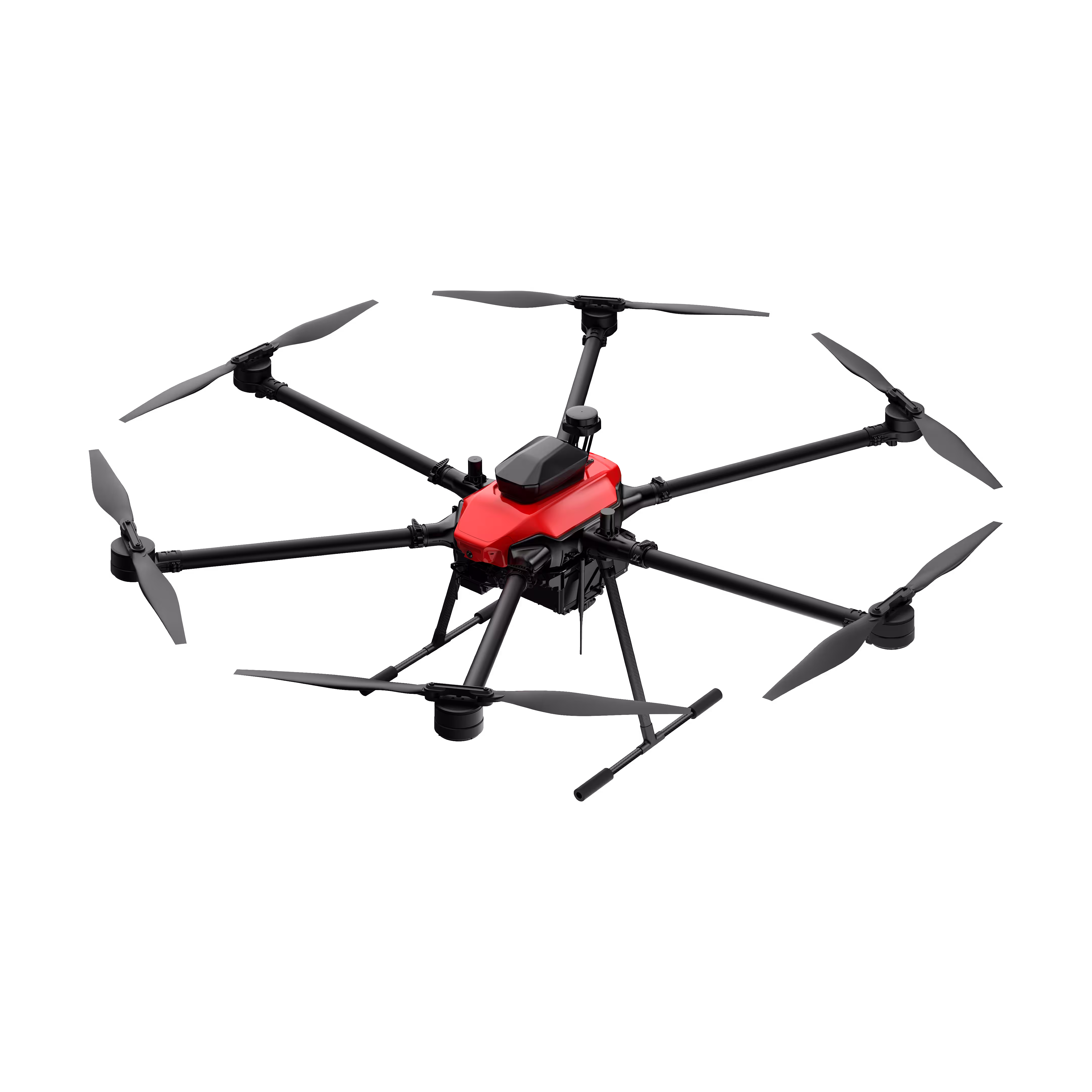
Skylle Ⅱ
Hexacopter Industrial Heavy-Lift Drone - 10kg Payload | 60min Flight Time | RTK cm-Level Positioning | IP54 Rated Read More
Learn MorePayload And Software
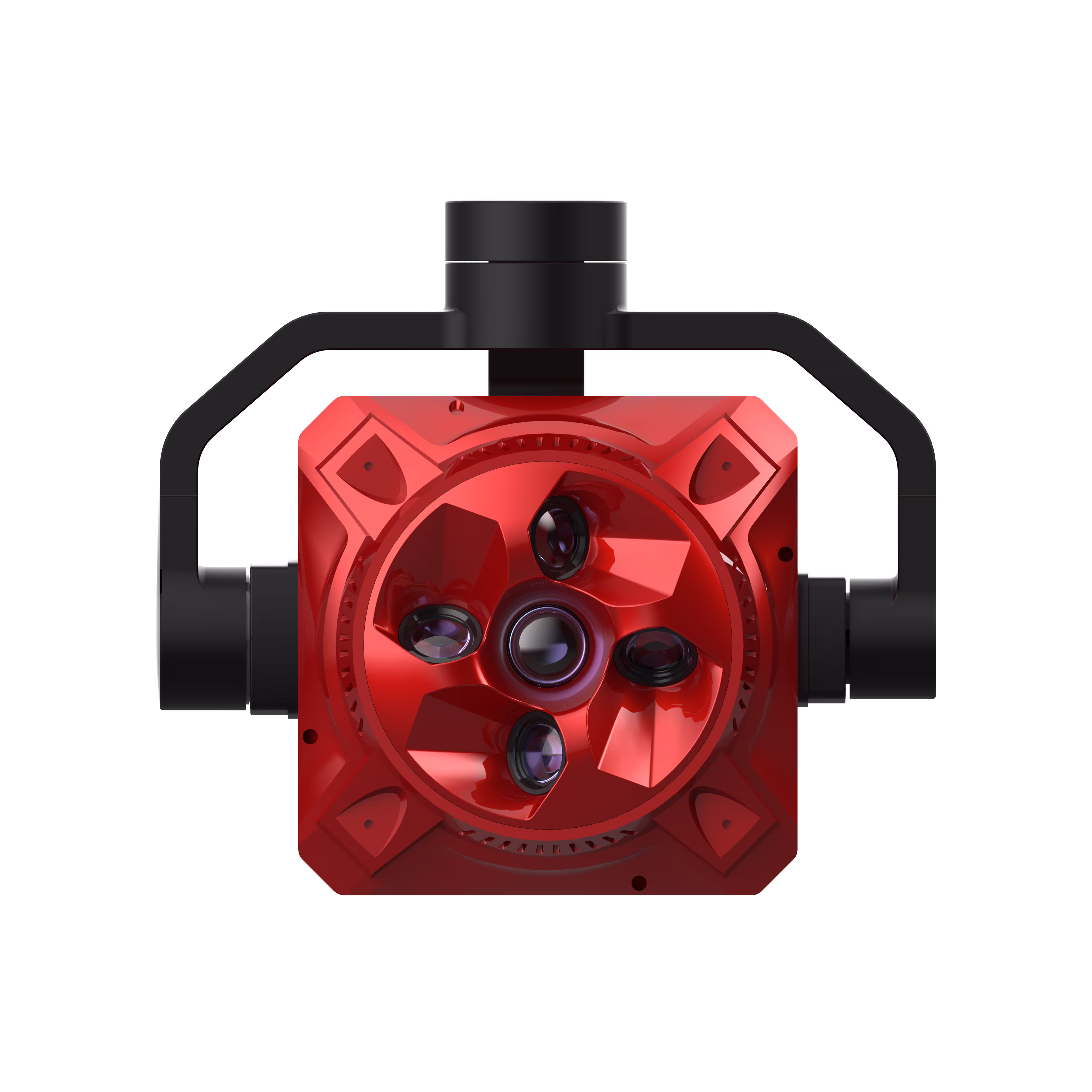
X4 Pro
MMC X4 Pro is a high-performance, multi-purpose aerial survey camera designed for 3D modeling and precision mapping. As a professional five-lens oblique photography system, it breaks through the limitations of traditional single-angle mapping cameras, providing an integrated, high-precision, and efficient aerial survey solution for various mapping scenarios. Read More
Learn MoreSkylle Ⅱ + MMC X4 Pro: Portable Precision Redefining Urban Planning Surveying & Mapping
In the fast-evolving landscape of urban planning, the demand for agile, high-precision surveying tools has never been greater. Cities need data-driven insights to optimize land use, design resilient infrastructure, and shape sustainable growth—all while navigating tight timelines and complex urban terrains. Enter the Skylle Ⅱ UAV paired with the MMC X4 Pro 5-lens oblique photography camera: a portable surveying & mapping solution engineered to empower urban planning professionals with efficiency, accuracy, and unmatched mobility.
Why Skylle Ⅱ + MMC X4 Pro for Urban Planning?
Urban planning requires more than just data—it demands portable, reliable, and high-fidelity data that captures the nuances of dynamic cityscapes. The Skylle Ⅱ and MMC X4 Pro combination delivers exactly that, merging cutting-edge UAV agility with next-gen imaging technology to redefine on-site surveying for urban planning projects.
1. Ultra-Portable Design: Urban Planning on the Go
At the core of this solution lies portability—a game-changer for urban planning teams operating across diverse city environments, from dense downtown districts to sprawling suburban zones.
- Skylle Ⅱ UAV: Built with a foldable, lightweight frame and quick-release components, the Skylle Ⅱ can be deployed in minutes, eliminating the need for bulky equipment or complex setup. Its compact design fits into standard backpacks, making it easy to transport between urban planning sites, even in areas with limited vehicle access.
- MMC X4 Pro Camera: Crafted with industrial-grade metal composite materials, the MMC X4 Pro balances structural durability with featherlight efficiency (body weight ≤900g, optimized for portability). Its integrated cable management and unified interface reduce clutter, ensuring seamless integration with Skylle Ⅱ for hassle-free fieldwork—critical for urban planning teams juggling multiple survey points in a single day .
For urban planning professionals, this means less time on logistics and more time on data capture—whether mapping a historic district, assessing a construction site, or updating city infrastructure blueprints.
2. Centimeter-Level Precision: Data You Can Trust for Urban Planning
Urban planning hinges on accuracy. The MMC X4 Pro, paired with Skylle Ⅱ’s RTK capability, delivers centimeter-level geospatial data to support precise decision-making in urban development.
- Mechanical Shutter & RTK Integration: The MMC X4 Pro’s mechanical shutter (shutter life ≥500,000 times) eliminates motion blur, while its built-in RTK module synchronizes with Skylle Ⅱ’s positioning system to ensure sub-centimeter accuracy in every image. This is indispensable for urban planning tasks like land boundary demarcation, elevation modeling, and utility mapping .
- 5-Lens Oblique Photography: Equipped with five high-resolution lenses (total pixels ≥220 million, single camera pixels ≥44 million), the MMC X4 Pro captures vertical and oblique imagery simultaneously, reconstructing 3D models with lifelike detail. For urban planning, this translates to realistic representations of buildings, terrain, and vegetation—key for visualizing proposed developments or analyzing existing urban fabric .
3. Efficiency Redefined: Maximize Urban Planning Productivity
Time is a critical resource in urban planning, and the Skylle Ⅱ + MMC X4 Pro solution is engineered for speed without compromising quality.
- Rapid Data Capture: With a single flight, the system covers up to 2 km² at a 5cm GSD (Ground Sample Distance), ensuring high-resolution data for large-scale urban planning projects. This efficiency reduces the number of flights needed, cutting project timelines significantly .
- Fast Data Transfer: The MMC X4 Pro’s plug-and-play storage module (USB 3.1 protocol) enables data transfer speeds of up to 600MB/s, while its Gigabit Ethernet port allows for wired high-speed downloads. Urban planning teams can process data on-site, accelerating insights and keeping projects on track .
4. Safety First: Navigate Urban Complexity with Confidence
Urban environments are rife with obstacles—from tall buildings to power lines. The Skylle Ⅱ’s omnidirectional obstacle avoidance sensors, combined with the MMC X4 Pro’s stable imaging, ensure safe, reliable operations in crowded city spaces.
- 360° Obstacle Avoidance: Skylle Ⅱ’s advanced sensor fusion technology detects and avoids obstacles in real time, minimizing risks during low-altitude flights—essential for urban planning surveys in dense urban areas.
- Real-Time Terrain Follow: The system’s terrain-following feature adjusts flight altitude dynamically, ensuring consistent data quality even over uneven terrain (e.g., hills, riverbanks)—a must for comprehensive urban planning that accounts for topographical variations .
Empowering Urban Planning: From Concept to Construction
Whether you’re drafting a master plan, updating zoning regulations, or monitoring infrastructure progress, the Skylle Ⅱ + MMC X4 Pro solution transforms how urban planning data is collected. Its portability lets you survey hard-to-reach areas; its precision ensures compliance with strict urban planning standards; and its efficiency lets you cover more ground in less time.
Ready to Elevate Your Urban Planning Workflow?
The Skylle Ⅱ + MMC X4 Pro isn’t just a surveying tool—it’s a catalyst for smarter, more sustainable urban planning. Contact us today to learn how this portable, high-performance solution can drive your next urban planning project forward.
Skylle Ⅱ + MMC X4 Pro: Where Portability Meets Precision—Shaping the Cities of Tomorrow, Today.

Full-Frame High-Performance Surveying & Mapping
Skylle Ⅱ + MMC X4 Pro: Full-frame high-performance urban planning solution with centimeter accuracy, 3 km²/flight@5cm GSD.
- Full-frame 45MP sensor captures detailed urban textures for precise planning.
- Centimeter-level accuracy without GCPs, ideal for urban site surveys.
- Covers 3 km²/flight@5cm GSD, boosting urban mapping efficiency.
- Rugged design endures harsh urban environments, ensuring reliability.
Drone Platform
Skylle Ⅱ
Hexacopter Industrial Heavy-Lift Drone - 10kg Payload | 60min Flight Time | RTK cm-Level Positioning | IP54 Rated Read More
Learn MorePayload And Software
X4 Pro
MMC X4 Pro is a high-performance, multi-purpose aerial survey camera designed for 3D modeling and precision mapping. As a professional five-lens oblique photography system, it breaks through the limitations of traditional single-angle mapping cameras, providing an integrated, high-precision, and efficient aerial survey solution for various mapping scenarios. Read More
Learn MoreSkylle Ⅱ + MMC X4 Pro: Full-Frame High-Performance Redefining Urban Planning Surveying
In the dynamic realm of urban planning, precision, efficiency, and reliability are non-negotiable. Cities demand full-frame, high-performance tools to capture detailed geospatial data that drives informed decisions—whether optimizing land use, designing resilient infrastructure, or monitoring urban growth. Introducing the Skylle Ⅱ UAV paired with the MMC X4 Pro full-frame 5-lens camera: a solution engineered to elevate urban planning with uncompromising image quality, centimeter-level accuracy, and rugged durability.
Why Full-Frame High-Performance Matters for Urban Planning
Urban planning requires data that reflects the complexity of cityscapes—from intricate building facades to subtle terrain variations. The MMC X4 Pro’s 45MP full-frame sensor (per lens) delivers unparalleled detail, ensuring every pixel contributes to precise 3D modeling, orthomosaics, and terrain analysis critical for urban planning . Paired with Skylle Ⅱ’s robust platform, this combination redefines what’s possible in urban planning surveying.
Key Features for Urban Planning Excellence
Full-Frame Precision: Capture Urban Details Like Never Before
The MMC X4 Pro’s full-frame sensor eliminates crop factors, capturing 45MP imagery with exceptional dynamic range and low-light performance. For urban planning, this means lifelike textures in historic districts, accurate color reproduction for vegetation mapping, and sharp edges for building footprint extraction—all essential for creating reliable urban planning deliverables.
Centimeter-Level Accuracy, No Ground Control Points Needed
Urban planning projects often face tight deadlines and limited access to GCPs. Skylle Ⅱ’s integrated RTK/PPK module, synchronized with MMC X4 Pro’s real-time POS data logging, delivers centimeter-level accuracy (horizontal: 1cm+1ppm; vertical: 1.5cm+1ppm) without ground control points. This accelerates urban planning workflows, from preliminary site surveys to final design validation.
High-Performance Efficiency: Cover 3 km² per Flight at 5cm GSD
Time is critical in urban planning. Skylle Ⅱ’s 80-minute flight time (with payload) and MMC X4 Pro’s 2.2-billion total pixels enable 3 km² coverage per flight at 5cm GSD—ideal for mapping large urban zones or updating city-wide plans in a single mission. Fast data transfer (600MB/s via USB 3.1) ensures urban planning teams spend less time on processing and more on analysis.
Rugged Reliability for Harsh Urban Environments
Urban planning doesn’t stop for bad weather. Skylle Ⅱ’s carbon-fiber airframe and IP54 rating withstand rain, dust, and temperatures from -20°C to 65°C, while MMC X4 Pro’s industrial-grade metal composite body ensures stable operation in high winds or extreme heat. This durability makes it the go-to choice for urban planning in challenging conditions.
Empowering Urban Planning: From Vision to Execution
Whether you’re modeling a new transit hub, analyzing flood risk zones, or updating zoning maps, the Skylle Ⅱ + MMC X4 Pro solution delivers the full-frame, high-performance data urban planning demands. Its precision reduces rework, its efficiency cuts project timelines, and its reliability ensures operations in any urban environment.
Elevate Your Urban Planning Today
Ready to transform urban planning with full-frame accuracy and high-performance efficiency? Choose Skylle Ⅱ + MMC X4 Pro—the ultimate surveying solution for modern cities.
Skylle Ⅱ + MMC X4 Pro: Where Full-Frame Precision Meets Urban Planning Excellence.