Geospatial
MMC Drones' Geospatial Solutions leverage advanced drone technology to deliver highly accurate aerial data for mapping, surveying, and infrastructure monitoring. Our drones capture precise geospatial information, enabling managers, surveyors, and engineers to make informed decisions throughout the project lifecycle. By automating data collection, we reduce costs, minimize risks to personnel, and optimize operational efficiency—ensuring faster, safer, and more reliable geospatial insights for industries like construction, agriculture, and urban planning.
Surveying And Mapping
MMC Drones delivers precise topographic surveys using advanced drone technology, generating 2D/3D maps and terrain models. Our solutions outperform traditional methods with faster data collection, lower costs, and centimeter-level accuracy - ideal for construction, mining, and land development. Automated workflows enhance safety and productivity while reducing errors.
Applications
Land Survey
MMC Drones revolutionize land surveying by quickly generating accurate 2D and 3D models, enabling efficient data collection over large areas. With advanced UAV technology, they enhance safety by minimizing personnel exposure to hazardous environments and reduce costs through automated, high-resolution mapping. Ideal for topographic surveys and construction planning, MMC Drones streamline workflows while delivering precise, actionable geospatial data.
Cadastral Survey
MMC Drones' Cadastral Survey Solutions leverage high-accuracy UAS technology to streamline land administration and property mapping. Our drones rapidly capture precise geospatial data, enabling the quick generation of digital cadastral models with centimeter-level accuracy. By replacing traditional ground surveys, we reduce time, costs, and manual errors while improving data reliability—ideal for governments, land registries, and real estate developers.

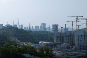
Urban Planning
MMC Drones' Urban Planning Solutions empower city planners and developers with high-precision 2D/3D modeling for smarter decision-making. Our drone-captured data seamlessly integrates with GIS platforms, delivering accurate visualizations of terrain, infrastructure, and development scenarios.
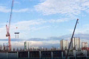
Construction
MMC Drones' Construction Solutions provide centimeter-accurate aerial data for all project phases - from site surveys to final verification. Our automated drone systems reduce survey time by 80% while delivering 3D models and progress tracking to optimize workflows, cut costs, and prevent delays.
Applications
Progress Management
MMC Drones' Progress Management uses automated aerial imaging to track construction with 75% time savings. Get cm-accurate 3D site models for better team coordination and schedule control. Integrates with existing project tools.
BIM
MMC Drones revolutionize Building Information Modeling (BIM) by delivering efficient and precise data capture solutions. Our advanced drone technology ensures accurate collection of asset information, streamlining BIM processes for enhanced project planning, design, and management. With high-quality data, MMC Drones empower teams to optimize workflows and achieve superior project outcomes.
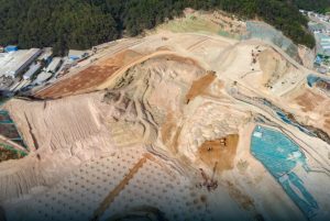
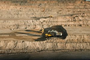
Earthwork
MMC Drones' Earthwork Solutions optimize excavation, grading, and material management with precise aerial data. Our drone-powered systems automate volume measurements of earth movements and stockpiles, delivering centimeter-accurate calculations up to 5x faster than manual surveys. Frequent flyovers track progress against designs, minimize over-excavation, and prevent costly rework—ensuring projects stay on budget and schedule.
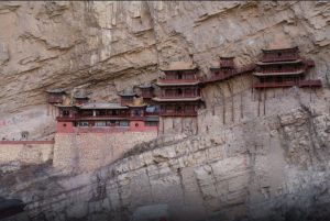
Heritage Preservation
MMC Drones delivers millimeter-accurate 3D reconstructions of heritage sites using advanced drone mapping. Our non-invasive technology enables precise condition monitoring, restoration planning, and digital archiving while protecting fragile structures. Ideal for conservationists and researchers.
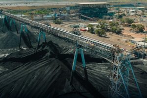
Mining
MMC Drones transforms mining operations with automated aerial surveys. Our solutions provide real-time stockpile analytics, pit monitoring, and hazard detection—reducing manual work by 90% while improving safety and productivity.
Applications
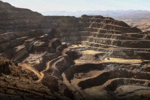
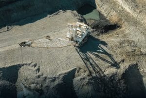
Mining Survey
MMC mining survey revolutionize data collection with drone-powered precision. Our technology delivers safer, faster stockpile measurements and pit modeling, achieving centimeter accuracy in hours instead of days. By replacing risky ground surveys, we reduce costs by 50% while improving data quality.
Facade High Wall
MMC drones transform facade high wall modeling in mining with safe, accurate 3D solutions. Advanced UAVs with cameras or LiDAR capture high-resolution data, creating precise 2D maps and 3D models. These geotagged models reduce risky manual surveys and enhance decision-making.
Asset Inspection
MMC asset inspection solution revolutionizes mining equipment maintenance through non-contact aerial inspections. Our drones capture high-resolution visual and thermal imagery of crushers, conveyors, and processing plants while operations continue.
Site Safety
MMC Drones enhances mining safety with automated aerial inspections. Our solutions capture high-resolution site data to detect hazards, monitor equipment, and track personnel in real-time. Drones reduce inspection risks by 90% versus manual methods while cutting survey time by 75%.
Precision Agriculture & Forestry
MMC precision agriculture & forestry solutions revolutionize land management through advanced aerial intelligence. Our drones capture high-resolution multispectral and LiDAR data for comprehensive crop health analysis and precise forest inventories. The system identifies tree species, measures biomass, and detects plant stress with 95% accuracy, while reducing survey time by 80% versus traditional methods. Farmers gain actionable insights for irrigation and treatment, while foresters obtain accurate timber volume calculations. Compatible with major GIS platforms for seamless data integration.
Applications
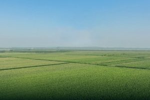
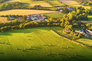
Precision Agriculture
MMC precision agriculture solutions transform farm management through intelligent aerial monitoring. Our drone systems enable rapid field scanning with multispectral sensors to assess crop health, soil conditions, and irrigation needs. The technology identifies disease outbreaks and nutrient deficiencies early, allowing targeted treatment that reduces chemical use by up to 30%. Automated data processing delivers actionable insights within hours, helping farmers optimize yields while cutting operational costs. Ideal for large-scale row crops, orchards, and vineyards.
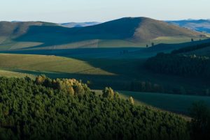
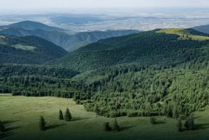
Forestry
MMC forestry solution revolutionizes forest inventory and management by offering efficient, accurate, and digitized data collection over large areas. Equipped with high-resolution imaging and mapping capabilities, drones streamline forest surveys, enabling precise tracking of tree count, health, and density. This aerial perspective enhances planning, monitoring, and sustainable forest management with reduced labor and time costs.